Taiping geodata
Taiping (Zhejiang) is a seat of a third-order administrative division; located in China in Asia/Shanghai (GMT+8) time zone. In our database, there are 1268 cities with bigger population. Compared to other cities in China, 70.9% of cities are located further ↑North; 89.4% of cities are located further ←West and 87.7% of cities have higher elevation than Taiping. Note1


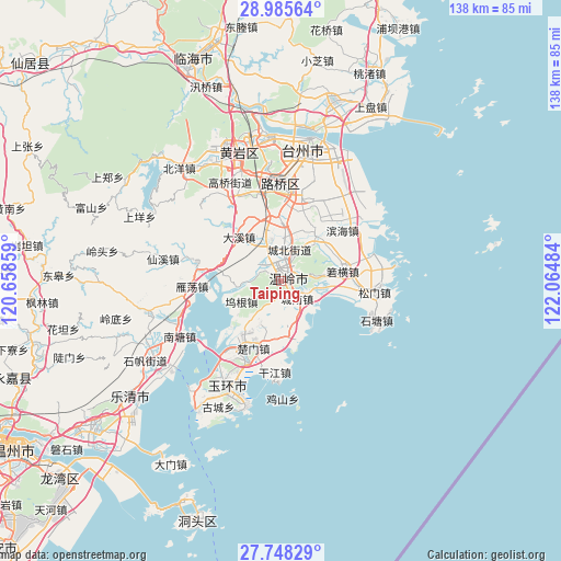
Taiping GPS coordinates[2]
28° 22' 7.572" North, 121° 21' 42.156" East
| Map corner | latitude | longitude |
|---|---|---|
| Upper-left | 28.98564°, | 120.65859° |
| Center: | 28.36877°, | 121.36171° |
| Lower-right: | 27.74829°, | 122.06484° |
| Map W x H: | 137.6×137.6 km | = 85.5×85.5mi |
| max Lat: | 53.31946° ⇑70.9% North |
| Taiping: | 28.36877° |
| min Lat: | ⇓29.1% South 18.22056° |
| min Long | Taiping | max Long |
| 75.07348° | 121.36171° | 134.28917° |
| W 89.4%⇐ | ⇒10.6% E |
Elevation
Elevation of Taiping is 12 m = 39 ft, and this is 472.8 m = 1551 ft below average elevation for this country.
| Max E: |
5622 m = 18445 ft | 87.7% |
| Avg. | 484.8 m = 1591 ft | |
| Taiping | 12 m = 39 ft | |
Min E: |
-3 m = -10 ft | 12.3% |
See also: China elevation on elevation.city.
Geographical zone
Taiping is located in North temperate zone (between Tropic of Cancer and the Arctic Circle). Distance of this Northern Tropic circle is 548.4 km =340.8 mi to South.| Distance of | km | miles | from Taiping |
|---|---|---|---|
| North Pole | 6852.8 | 4258.1 | to North |
| Arctic Circle | 4246.9 | 2638.9 | to North |
| Tropic Cancer | 548.4 | 340.8 | to South |
| Equator | 3154.3 | 1960 | to South |


Nearby cities:
15 places around Taiping: (largest is in red/bold)
• Chengbei
8.3 km =5.2 mi,  10°
10°
• Chengdong
3.9 km =2.4 mi,  28°
28°
• Chengnan
6 km =3.7 mi,  141°
141°
• Chengxi
1.9 km =1.2 mi,  336°
336°
• Daxi
15.4 km =9.6 mi,  314°
314°
• Hengfeng
7.6 km =4.7 mi, 343°
• Huwu
15.7 km =9.8 mi,  281°
281°
• Qinggang
15 km =9.3 mi,  210°
210°
• Shamen
14.2 km =8.8 mi,  173°
173°
• Shiqiaotou
8.9 km =5.5 mi,  99°
99°
• Wenling
2.3 km =1.4 mi,  71°
71°
• Wugen
10.4 km =6.5 mi,  241°
241°
• Xinhe
15.3 km =9.5 mi, 34°
• Xinqiao
17.6 km =10.9 mi,  16°
16°
• Zeguo
15.9 km =9.9 mi,  359°
359°
Sources, notices
• [Note1] Compared only with cities in China existing in our database
• [Src1] Map data: © OpenStreetMap contributors (CC-BY-SA)
• [Src2] Other city data from geonames.org with taken over terms of usage.
• [Src3] Geographical zone / Annual Mean Temperature by Robert A. Rohde @ Wikipedia
