Chengdong geodata
Chengdong (Zhejiang) is a seat of a fourth-order administrative division; located in China in Asia/Shanghai (GMT+8) time zone. In our database, there are 1268 cities with bigger population. Compared to other cities in China, 70.6% of cities are located further ↑North; 89.5% of cities are located further ←West and 99.4% of cities have higher elevation than Chengdong. Note1


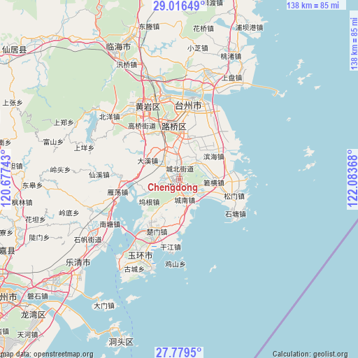
Chengdong GPS coordinates[2]
28° 23' 59.28" North, 121° 22' 49.98" East
| Map corner | latitude | longitude |
|---|---|---|
| Upper-left | 29.01649°, | 120.67743° |
| Center: | 28.3998°, | 121.38055° |
| Lower-right: | 27.7795°, | 122.08368° |
| Map W x H: | 137.5×137.5 km | = 85.4×85.4mi |
| max Lat: | 53.31946° ⇑70.6% North |
| Chengdong: | 28.3998° |
| min Lat: | ⇓29.4% South 18.22056° |
| min Long | Chengdong | max Long |
| 75.07348° | 121.38055° | 134.28917° |
| W 89.5%⇐ | ⇒10.5% E |
Elevation
Elevation of Chengdong is 2 m = 7 ft, and this is 482.8 m = 1584 ft below average elevation for this country.
| Max E: |
5622 m = 18445 ft | 99.4% |
| Avg. | 484.8 m = 1591 ft | |
| Chengdong | 2 m = 7 ft | |
Min E: |
-3 m = -10 ft | 0.6% |
See also: China elevation on elevation.city.
Geographical zone
Chengdong is located in North temperate zone (between Tropic of Cancer and the Arctic Circle). Distance of this Northern Tropic circle is 551.8 km =342.9 mi to South.| Distance of | km | miles | from Chengdong |
|---|---|---|---|
| North Pole | 6849.3 | 4256 | to North |
| Arctic Circle | 4243.4 | 2636.7 | to North |
| Tropic Cancer | 551.8 | 342.9 | to South |
| Equator | 3157.8 | 1962.2 | to South |


Nearby cities:
15 places around Chengdong: (largest is in red/bold)
• Chengbei
4.7 km =2.9 mi,  356°
356°
• Chengnan
8.4 km =5.2 mi,  167°
167°
• Chengxi
3.1 km =1.9 mi,  236°
236°
• Daxi
14.8 km =9.2 mi,  300°
300°
• Fengjiang
15.6 km =9.7 mi, 357°
• Hengfeng
5.5 km =3.4 mi,  313°
313°
• Hengjie
15.7 km =9.8 mi,  20°
20°
• Huwu
17.2 km =10.7 mi,  269°
269°
• Shiqiaotou
8.4 km =5.2 mi,  125°
125°
• Taiping
3.9 km =2.4 mi,  208°
208°
• Wenling
2.8 km =1.7 mi, 172°
• Wugen
13.8 km =8.6 mi,  232°
232°
• Xinhe
11.4 km =7.1 mi,  37°
37°
• Xinqiao
13.8 km =8.6 mi,  12°
12°
• Zeguo
12.6 km =7.8 mi,  351°
351°
Sources, notices
• [Note1] Compared only with cities in China existing in our database
• [Src1] Map data: © OpenStreetMap contributors (CC-BY-SA)
• [Src2] Other city data from geonames.org with taken over terms of usage.
• [Src3] Geographical zone / Annual Mean Temperature by Robert A. Rohde @ Wikipedia
