Chengnan geodata
Chengnan (Zhejiang) is a seat of a fourth-order administrative division; located in China in Asia/Shanghai (GMT+8) time zone. In our database, there are 1268 cities with bigger population. Compared to other cities in China, 71.2% of cities are located further ↑North; 89.6% of cities are located further ←West and 84.3% of cities have higher elevation than Chengnan. Note1


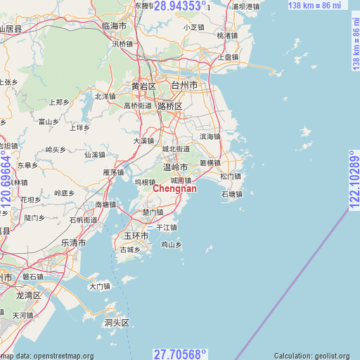
Chengnan GPS coordinates[2]
28° 19' 35.076" North, 121° 23' 59.136" East
| Map corner | latitude | longitude |
|---|---|---|
| Upper-left | 28.94353°, | 120.69664° |
| Center: | 28.32641°, | 121.39976° |
| Lower-right: | 27.70568°, | 122.10289° |
| Map W x H: | 137.6×137.6 km | = 85.5×85.5mi |
| max Lat: | 53.31946° ⇑71.2% North |
| Chengnan: | 28.32641° |
| min Lat: | ⇓28.8% South 18.22056° |
| min Long | Chengnan | max Long |
| 75.07348° | 121.39976° | 134.28917° |
| W 89.6%⇐ | ⇒10.4% E |
Elevation
Elevation of Chengnan is 17 m = 56 ft, and this is 467.8 m = 1535 ft below average elevation for this country.
| Max E: |
5622 m = 18445 ft | 84.3% |
| Avg. | 484.8 m = 1591 ft | |
| Chengnan | 17 m = 56 ft | |
Min E: |
-3 m = -10 ft | 15.7% |
See also: China elevation on elevation.city.
Geographical zone
Chengnan is located in North temperate zone (between Tropic of Cancer and the Arctic Circle). Distance of this Northern Tropic circle is 543.7 km =337.8 mi to South.| Distance of | km | miles | from Chengnan |
|---|---|---|---|
| North Pole | 6857.5 | 4261.1 | to North |
| Arctic Circle | 4251.6 | 2641.8 | to North |
| Tropic Cancer | 543.7 | 337.8 | to South |
| Equator | 3149.6 | 1957.1 | to South |


Nearby cities:
15 places around Chengnan: (largest is in red/bold)
• Chengbei
13.1 km =8.1 mi,  350°
350°
• Chengdong
8.4 km =5.2 mi, 347°
• Chengxi
7.8 km =4.8 mi,  325°
325°
• Chumen
15.8 km =9.8 mi,  221°
221°
• Ganjiang
19 km =11.8 mi,  194°
194°
• Hengfeng
13.3 km =8.3 mi, 334°
• Huwu
20.7 km =12.9 mi,  292°
292°
• Longxi
17.1 km =10.6 mi,  213°
213°
• Qinggang
14 km =8.7 mi,  233°
233°
• Shamen
9.7 km =6 mi, 193°
• Shiqiaotou
6 km =3.7 mi,  56°
56°
• Taiping
6 km =3.7 mi,  321°
321°
• Wenling
5.6 km =3.5 mi,  344°
344°
• Wugen
12.9 km =8 mi,  269°
269°
• Xinhe
17.9 km =11.1 mi,  16°
16°
Sources, notices
• [Note1] Compared only with cities in China existing in our database
• [Src1] Map data: © OpenStreetMap contributors (CC-BY-SA)
• [Src2] Other city data from geonames.org with taken over terms of usage.
• [Src3] Geographical zone / Annual Mean Temperature by Robert A. Rohde @ Wikipedia
