Qingyuan geodata
Qingyuan (Gansu) is a seat of a third-order administrative division; located in China in Asia/Shanghai (GMT+8) time zone. In our database, there are 1268 cities with bigger population. Compared to other cities in China, 75.3% of cities are located further ↓South; 90% of cities are located further →East and 94.9% of cities have lower elevation than Qingyuan. Note1


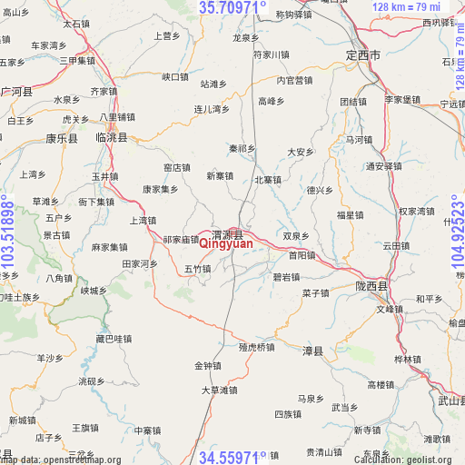
Qingyuan GPS coordinates[2]
35° 8' 12.264" North, 104° 13' 19.56" East
| Map corner | latitude | longitude |
|---|---|---|
| Upper-left | 35.70971°, | 103.51898° |
| Center: | 35.13674°, | 104.2221° |
| Lower-right: | 34.55971°, | 104.92523° |
| Map W x H: | 127.9×127.9 km | = 79.5×79.5mi |
| max Lat: | 53.31946° ⇑24.7% North |
| Qingyuan: | 35.13674° |
| min Lat: | ⇓75.3% South 18.22056° |
| min Long | Qingyuan | max Long |
| 75.07348° | 104.2221° | 134.28917° |
| W 10%⇐ | ⇒90% E |
Elevation
Elevation of Qingyuan is 2071 m = 6795 ft, and this is 1586.2 m = 5204 ft above average elevation for this country.
| Max E: |
5622 m = 18445 ft | 5.1% |
| Qingyuan | 2071 m 6795 ft | |
| Avg. | 484.8 m = 1591 ft | |
Min E: |
-3 m = -10 ft | 94.9% |
See also: China elevation on elevation.city.
Geographical zone
Qingyuan is located in North temperate zone (between Tropic of Cancer and the Arctic Circle). Distance of this Northern Tropic circle is 1300.9 km =808.3 mi to South.| Distance of | km | miles | from Qingyuan |
|---|---|---|---|
| North Pole | 6100.2 | 3790.5 | to North |
| Arctic Circle | 3494.3 | 2171.3 | to North |
| Tropic Cancer | 1300.9 | 808.3 | to South |
| Equator | 3906.8 | 2427.6 | to South |


Nearby cities:
15 places around Qingyuan: (largest is in red/bold)
• Bailin
48.9 km =30.4 mi,  211°
211°
• Bajiao
49.3 km =30.6 mi,  255°
255°
• Caizi Zhen
28.1 km =17.5 mi,  125°
125°
• Fucheng
53.7 km =33.4 mi,  299°
299°
• Gongchang Zhen
41 km =25.5 mi,  111°
111°
• Lianlu
45.4 km =28.2 mi,  252°
252°
• Santai Zhen
50.4 km =31.3 mi, 114°
• Taoyang
44.6 km =27.7 mi,  311°
311°
• Tianjiahe
26.9 km =16.7 mi, 251°
• Wenfeng Zhen
48 km =29.8 mi,  115°
115°
• Xiacheng
41.3 km =25.7 mi, 247°
• Xiaozhai
58.5 km =36.4 mi,  199°
199°
• Yangzhuang
18.3 km =11.4 mi, 245°
• Yeliguan
54.6 km =33.9 mi, 249°
• Zangbawa
43.7 km =27.2 mi,  228°
228°
Sources, notices
• [Note1] Compared only with cities in China existing in our database
• [Src1] Map data: © OpenStreetMap contributors (CC-BY-SA)
• [Src2] Other city data from geonames.org with taken over terms of usage.
• [Src3] Geographical zone / Annual Mean Temperature by Robert A. Rohde @ Wikipedia
