Wandian geodata
Wandian (Hubei) is a seat of a fourth-order administrative division; located in China in Asia/Shanghai (GMT+8) time zone. In our database, there are 1268 cities with bigger population. Compared to other cities in China, 60.3% of cities are located further ↓South; 54.4% of cities are located further →East and 63.1% of cities have higher elevation than Wandian. Note1


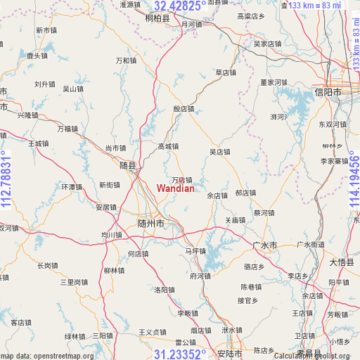
Wandian GPS coordinates[2]
31° 49' 58.152" North, 113° 29' 29.148" East
| Map corner | latitude | longitude |
|---|---|---|
| Upper-left | 32.42825°, | 112.78831° |
| Center: | 31.83282°, | 113.49143° |
| Lower-right: | 31.23352°, | 114.19456° |
| Map W x H: | 132.8×132.8 km | = 82.5×82.5mi |
| max Lat: | 53.31946° ⇑39.7% North |
| Wandian: | 31.83282° |
| min Lat: | ⇓60.3% South 18.22056° |
| min Long | Wandian | max Long |
| 75.07348° | 113.49143° | 134.28917° |
| W 45.6%⇐ | ⇒54.4% E |
Elevation
Elevation of Wandian is 82 m = 269 ft, and this is 402.8 m = 1322 ft below average elevation for this country.
| Max E: |
5622 m = 18445 ft | 63.1% |
| Avg. | 484.8 m = 1591 ft | |
| Wandian | 82 m = 269 ft | |
Min E: |
-3 m = -10 ft | 36.9% |
See also: China elevation on elevation.city.
Geographical zone
Wandian is located in North temperate zone (between Tropic of Cancer and the Arctic Circle). Distance of this Northern Tropic circle is 933.6 km =580.1 mi to South.| Distance of | km | miles | from Wandian |
|---|---|---|---|
| North Pole | 6467.6 | 4018.8 | to North |
| Arctic Circle | 3861.7 | 2399.5 | to North |
| Tropic Cancer | 933.6 | 580.1 | to South |
| Equator | 3539.5 | 2199.3 | to South |


Nearby cities:
15 places around Wandian: (largest is in red/bold)
• Dayanpo
25.4 km =15.8 mi,  191°
191°
• Fengjiang
21.4 km =13.3 mi,  317°
317°
• Gaocheng
13.5 km =8.4 mi,  339°
339°
• Guanmiao
24.7 km =15.3 mi,  125°
125°
• Haodian
24.4 km =15.2 mi,  100°
100°
• Lishan
18.8 km =11.7 mi,  278°
278°
• Maping
26.4 km =16.4 mi,  167°
167°
• Nanjiao
18.9 km =11.7 mi,  225°
225°
• Suizhou
18.2 km =11.3 mi,  221°
221°
• Wudian
17.8 km =11.1 mi,  53°
53°
• Xihe
16.5 km =10.3 mi, 188°
• Xinglong
17.4 km =10.8 mi,  139°
139°
• Xinjie
26.5 km =16.5 mi,  266°
266°
• Yindian
26.6 km =16.5 mi,  2°
2°
• Yudian
14.6 km =9.1 mi,  111°
111°
Sources, notices
• [Note1] Compared only with cities in China existing in our database
• [Src1] Map data: © OpenStreetMap contributors (CC-BY-SA)
• [Src2] Other city data from geonames.org with taken over terms of usage.
• [Src3] Geographical zone / Annual Mean Temperature by Robert A. Rohde @ Wikipedia
