Xihe geodata
Xihe (Hubei) is a seat of a fourth-order administrative division; located in China in Asia/Shanghai (GMT+8) time zone. With population of 90,422 people, there are 471 cities with bigger population in this country. Compared to other cities in China, 59.4% of cities are located further ↓South; 54.6% of cities are located further →East and 67.2% of cities have higher elevation than Xihe. Note1


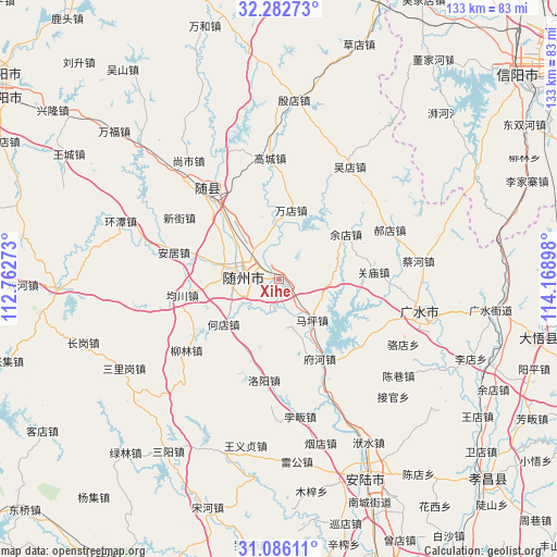
Xihe GPS coordinates[2]
31° 41' 10.86" North, 113° 27' 57.06" East
| Map corner | latitude | longitude |
|---|---|---|
| Upper-left | 32.28273°, | 112.76273° |
| Center: | 31.68635°, | 113.46585° |
| Lower-right: | 31.08611°, | 114.16898° |
| Map W x H: | 133.1×133.1 km | = 82.7×82.7mi |
| max Lat: | 53.31946° ⇑40.6% North |
| Xihe: | 31.68635° |
| min Lat: | ⇓59.4% South 18.22056° |
| min Long | Xihe | max Long |
| 75.07348° | 113.46585° | 134.28917° |
| W 45.4%⇐ | ⇒54.6% E |
Elevation
Elevation of Xihe is 64 m = 210 ft, and this is 420.8 m = 1381 ft below average elevation for this country.
| Max E: |
5622 m = 18445 ft | 67.2% |
| Avg. | 484.8 m = 1591 ft | |
| Xihe | 64 m = 210 ft | |
Min E: |
-3 m = -10 ft | 32.8% |
See also: Xihe elevation on elevation.city.
Geographical zone
Xihe is located in North temperate zone (between Tropic of Cancer and the Arctic Circle). Distance of this Northern Tropic circle is 917.3 km =570 mi to South.| Distance of | km | miles | from Xihe |
|---|---|---|---|
| North Pole | 6483.9 | 4028.9 | to North |
| Arctic Circle | 3878 | 2409.7 | to North |
| Tropic Cancer | 917.3 | 570 | to South |
| Equator | 3523.2 | 2189.2 | to South |


Nearby cities:
15 places around Xihe: (largest is in red/bold)
• Anju
25.9 km =16.1 mi,  284°
284°
• Changling
21.7 km =13.5 mi,  149°
149°
• Dayanpo
9 km =5.6 mi,  197°
197°
• Fuhe
21.8 km =13.5 mi, 154°
• Guanmiao
22.7 km =14.1 mi,  84°
84°
• Hedian
17.1 km =10.6 mi,  232°
232°
• Junchuan
23.7 km =14.7 mi,  260°
260°
• Lishan
25 km =15.5 mi,  319°
319°
• Luoyang
24 km =14.9 mi,  189°
189°
• Maping
12.4 km =7.7 mi,  139°
139°
• Nanjiao
11.4 km =7.1 mi,  285°
285°
• Suizhou
10.1 km =6.3 mi, 285°
• Wandian
16.5 km =10.3 mi,  8°
8°
• Xinglong
14 km =8.7 mi, 77°
• Yudian
19.3 km =12 mi,  55°
55°
Sources, notices
• [Note1] Compared only with cities in China existing in our database
• [Src1] Map data: © OpenStreetMap contributors (CC-BY-SA)
• [Src2] Other city data from geonames.org with taken over terms of usage.
• [Src3] Geographical zone / Annual Mean Temperature by Robert A. Rohde @ Wikipedia
