Xinglong geodata
Xinglong (Hubei) is a seat of a fourth-order administrative division; located in China in Asia/Shanghai (GMT+8) time zone. In our database, there are 1268 cities with bigger population. Compared to other cities in China, 59.6% of cities are located further ↓South; 53.6% of cities are located further →East and 62.9% of cities have higher elevation than Xinglong. Note1


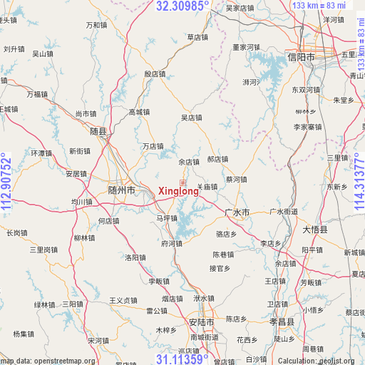
Xinglong GPS coordinates[2]
31° 42' 49.14" North, 113° 36' 38.304" East
| Map corner | latitude | longitude |
|---|---|---|
| Upper-left | 32.30985°, | 112.90752° |
| Center: | 31.71365°, | 113.61064° |
| Lower-right: | 31.11359°, | 114.31377° |
| Map W x H: | 133×133 km | = 82.6×82.6mi |
| max Lat: | 53.31946° ⇑40.4% North |
| Xinglong: | 31.71365° |
| min Lat: | ⇓59.6% South 18.22056° |
| min Long | Xinglong | max Long |
| 75.07348° | 113.61064° | 134.28917° |
| W 46.4%⇐ | ⇒53.6% E |
Elevation
Elevation of Xinglong is 83 m = 272 ft, and this is 401.8 m = 1318 ft below average elevation for this country.
| Max E: |
5622 m = 18445 ft | 62.9% |
| Avg. | 484.8 m = 1591 ft | |
| Xinglong | 83 m = 272 ft | |
Min E: |
-3 m = -10 ft | 37.1% |
See also: China elevation on elevation.city.
Geographical zone
Xinglong is located in North temperate zone (between Tropic of Cancer and the Arctic Circle). Distance of this Northern Tropic circle is 920.3 km =571.8 mi to South.| Distance of | km | miles | from Xinglong |
|---|---|---|---|
| North Pole | 6480.8 | 4027 | to North |
| Arctic Circle | 3874.9 | 2407.8 | to North |
| Tropic Cancer | 920.3 | 571.8 | to South |
| Equator | 3526.2 | 2191.1 | to South |


Nearby cities:
15 places around Xinglong: (largest is in red/bold)
• Baolin
25 km =15.5 mi,  100°
100°
• Caihe
19.2 km =11.9 mi,  86°
86°
• Changling
21.9 km =13.6 mi,  187°
187°
• Dayanpo
20.1 km =12.5 mi,  234°
234°
• Fuhe
23.1 km =14.4 mi, 190°
• Guanmiao
9 km =5.6 mi, 96°
• Haodian
15.5 km =9.6 mi,  55°
55°
• Luodian
24.4 km =15.2 mi,  139°
139°
• Maping
13.8 km =8.6 mi,  204°
204°
• Nanjiao
24.7 km =15.3 mi,  269°
269°
• Suizhou
23.4 km =14.5 mi, 269°
• Wandian
17.4 km =10.8 mi,  319°
319°
• Wudian
24 km =14.9 mi,  7°
7°
• Xihe
14 km =8.7 mi,  257°
257°
• Yudian
8.1 km =5 mi,  16°
16°
Sources, notices
• [Note1] Compared only with cities in China existing in our database
• [Src1] Map data: © OpenStreetMap contributors (CC-BY-SA)
• [Src2] Other city data from geonames.org with taken over terms of usage.
• [Src3] Geographical zone / Annual Mean Temperature by Robert A. Rohde @ Wikipedia
