Suizhou geodata
Suizhou (Hubei) is a populated place; located in China in Asia/Shanghai (GMT+8) time zone. With population of 323,945 people, there are 172 cities with bigger population in this country. Compared to other cities in China, 59.6% of cities are located further ↓South; 55.2% of cities are located further →East and 66.4% of cities have higher elevation than Suizhou. Note1


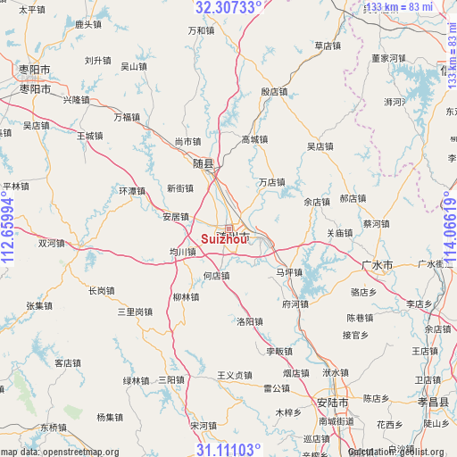
Suizhou GPS coordinates[2]
31° 42' 39.996" North, 113° 21' 47.016" East
| Map corner | latitude | longitude |
|---|---|---|
| Upper-left | 32.30733°, | 112.65994° |
| Center: | 31.71111°, | 113.36306° |
| Lower-right: | 31.11103°, | 114.06619° |
| Map W x H: | 133×133 km | = 82.6×82.6mi |
| max Lat: | 53.31946° ⇑40.4% North |
| Suizhou: | 31.71111° |
| min Lat: | ⇓59.6% South 18.22056° |
| min Long | Suizhou | max Long |
| 75.07348° | 113.36306° | 134.28917° |
| W 44.8%⇐ | ⇒55.2% E |
Elevation
Elevation of Suizhou is 67 m = 220 ft, and this is 417.8 m = 1371 ft below average elevation for this country.
| Max E: |
5622 m = 18445 ft | 66.4% |
| Avg. | 484.8 m = 1591 ft | |
| Suizhou | 67 m = 220 ft | |
Min E: |
-3 m = -10 ft | 33.6% |
See also: Suizhou elevation on elevation.city.
Geographical zone
Suizhou is located in North temperate zone (between Tropic of Cancer and the Arctic Circle). Distance of this Northern Tropic circle is 920 km =571.7 mi to South.| Distance of | km | miles | from Suizhou |
|---|---|---|---|
| North Pole | 6481.1 | 4027.2 | to North |
| Arctic Circle | 3875.2 | 2407.9 | to North |
| Tropic Cancer | 920 | 571.7 | to South |
| Equator | 3525.9 | 2190.9 | to South |


Nearby cities:
15 places around Suizhou: (largest is in red/bold)
• Anju
15.8 km =9.8 mi,  283°
283°
• Dayanpo
13.4 km =8.3 mi,  148°
148°
• Gaocheng
27.3 km =17 mi,  15°
15°
• Hedian
13.7 km =8.5 mi,  196°
196°
• Junchuan
15.2 km =9.4 mi,  244°
244°
• Lishan
17.5 km =10.9 mi,  338°
338°
• Liulin
22.7 km =14.1 mi,  212°
212°
• Luoyang
27.1 km =16.8 mi,  167°
167°
• Maping
21.6 km =13.4 mi,  124°
124°
• Nanjiao
1.3 km =0.8 mi, 280°
• Wandian
18.2 km =11.3 mi,  41°
41°
• Xihe
10.1 km =6.3 mi,  105°
105°
• Xinglong
23.4 km =14.5 mi,  89°
89°
• Xinjie
18.6 km =11.6 mi,  309°
309°
• Yudian
26.9 km =16.7 mi,  72°
72°
Sources, notices
• [Note1] Compared only with cities in China existing in our database
• [Src1] Map data: © OpenStreetMap contributors (CC-BY-SA)
• [Src2] Other city data from geonames.org with taken over terms of usage.
• [Src3] Geographical zone / Annual Mean Temperature by Robert A. Rohde @ Wikipedia
