Maping geodata
Maping (Hubei) is a seat of a fourth-order administrative division; located in China in Asia/Shanghai (GMT+8) time zone. In our database, there are 1268 cities with bigger population. Compared to other cities in China, 59% of cities are located further ↓South; 54% of cities are located further →East and 67.4% of cities have higher elevation than Maping. Note1


Maping GPS coordinates[2]
31° 36' 3.348" North, 113° 33' 1.98" East
| Map corner | latitude | longitude |
|---|---|---|
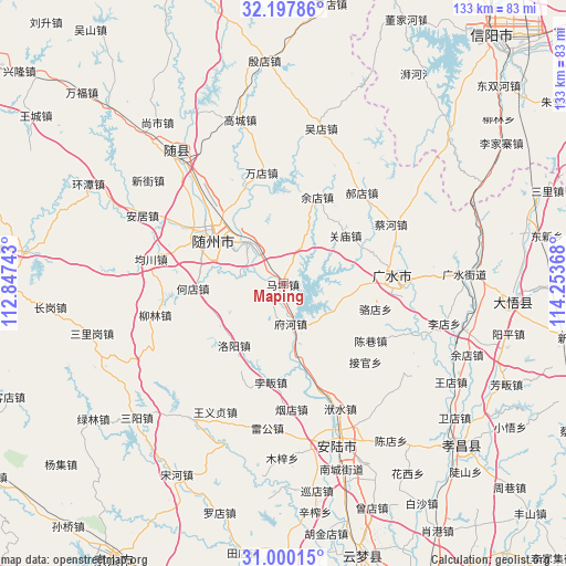
| Upper-left | 32.19786°, | 112.84743° |
| Center: | 31.60093°, | 113.55055° |
| Lower-right: | 31.00015°, | 114.25368° |
| Map W x H: | 133.2×133.2 km | = 82.8×82.8mi |
| max Lat: | 53.31946° ⇑41% North |
| Maping: | 31.60093° |
| min Lat: | ⇓59% South 18.22056° |
| min Long | Maping | max Long |
| 75.07348° | 113.55055° | 134.28917° |
| W 46%⇐ | ⇒54% E |
Elevation
Elevation of Maping is 63 m = 207 ft, and this is 421.8 m = 1384 ft below average elevation for this country.
| Max E: |
5622 m = 18445 ft | 67.4% |
| Avg. | 484.8 m = 1591 ft | |
| Maping | 63 m = 207 ft | |
Min E: |
-3 m = -10 ft | 32.6% |
See also: China elevation on elevation.city.
Geographical zone
Maping is located in North temperate zone (between Tropic of Cancer and the Arctic Circle). Distance of this Northern Tropic circle is 907.8 km =564.1 mi to South.| Distance of | km | miles | from Maping |
|---|---|---|---|
| North Pole | 6493.4 | 4034.8 | to North |
| Arctic Circle | 3887.5 | 2415.6 | to North |
| Tropic Cancer | 907.8 | 564.1 | to South |
| Equator | 3513.7 | 2183.3 | to South |


Nearby cities:
15 places around Maping: (largest is in red/bold)
• Beifan
24.3 km =15.1 mi,  186°
186°
• Changling
9.7 km =6 mi,  162°
162°
• Chenxiang
24.6 km =15.3 mi,  123°
123°
• Dayanpo
10.7 km =6.6 mi,  274°
274°
• Fuhe
10.3 km =6.4 mi,  171°
171°
• Guanmiao
18.6 km =11.6 mi,  51°
51°
• Hedian
21.7 km =13.5 mi, 267°
• Luodian
22.5 km =14 mi,  105°
105°
• Luoyang
18.5 km =11.5 mi,  219°
219°
• Nanjiao
22.8 km =14.2 mi,  303°
303°
• Pinglin
21.3 km =13.2 mi, 165°
• Suizhou
21.6 km =13.4 mi, 304°
• Xihe
12.4 km =7.7 mi,  319°
319°
• Xinglong
13.8 km =8.6 mi,  24°
24°
• Yudian
21.8 km =13.5 mi, 21°
Sources, notices
• [Note1] Compared only with cities in China existing in our database
• [Src1] Map data: © OpenStreetMap contributors (CC-BY-SA)
• [Src2] Other city data from geonames.org with taken over terms of usage.
• [Src3] Geographical zone / Annual Mean Temperature by Robert A. Rohde @ Wikipedia
