Qingyang geodata
Qingyang (Shanxi) is a seat of a third-order administrative division; located in China in Asia/Shanghai (GMT+8) time zone. In our database, there are 1268 cities with bigger population. Compared to other cities in China, 77.6% of cities are located further ↓South; 54.9% of cities are located further →East and 87.9% of cities have lower elevation than Qingyang. Note1


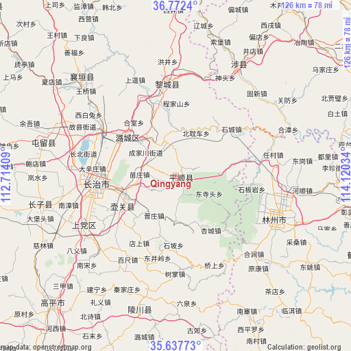
Qingyang GPS coordinates[2]
36° 12' 25.632" North, 113° 25' 1.956" East
| Map corner | latitude | longitude |
|---|---|---|
| Upper-left | 36.7724°, | 112.71409° |
| Center: | 36.20712°, | 113.41721° |
| Lower-right: | 35.63773°, | 114.12034° |
| Map W x H: | 126.2×126.2 km | = 78.4×78.4mi |
| max Lat: | 53.31946° ⇑22.4% North |
| Qingyang: | 36.20712° |
| min Lat: | ⇓77.6% South 18.22056° |
| min Long | Qingyang | max Long |
| 75.07348° | 113.41721° | 134.28917° |
| W 45.1%⇐ | ⇒54.9% E |
Elevation
Elevation of Qingyang is 1180 m = 3871 ft, and this is 695.2 m = 2281 ft above average elevation for this country.
| Max E: |
5622 m = 18445 ft | 12.1% |
| Qingyang | 1180 m 3871 ft | |
| Avg. | 484.8 m = 1591 ft | |
Min E: |
-3 m = -10 ft | 87.9% |
See also: China elevation on elevation.city.
Geographical zone
Qingyang is located in North temperate zone (between Tropic of Cancer and the Arctic Circle). Distance of this Northern Tropic circle is 1419.9 km =882.3 mi to South.| Distance of | km | miles | from Qingyang |
|---|---|---|---|
| North Pole | 5981.2 | 3716.5 | to North |
| Arctic Circle | 3375.3 | 2097.3 | to North |
| Tropic Cancer | 1419.9 | 882.3 | to South |
| Equator | 4025.9 | 2501.6 | to South |


Nearby cities:
15 places around Qingyang: (largest is in red/bold)
• Changzhi
28.1 km =17.5 mi,  264°
264°
• Chongwen
50.3 km =31.3 mi,  197°
197°
• Danzhu
50.8 km =31.6 mi, 259°
• Daxinzhuang
30.1 km =18.7 mi,  275°
275°
• Guhan
50.6 km =31.4 mi,  316°
316°
• Handian
38 km =23.6 mi,  241°
241°
• Hebi
77.7 km =48.3 mi,  116°
116°
• Hecun
71.9 km =44.7 mi,  59°
59°
• Kaiyuan
39.5 km =24.5 mi,  113°
113°
• Lihou
33.2 km =20.6 mi,  352°
352°
• Linjiang
49.8 km =30.9 mi,  285°
285°
• Linshui
74.6 km =46.4 mi,  71°
71°
• Longquan
23.1 km =14.4 mi, 244°
• Luhua
22.1 km =13.7 mi,  308°
308°
• Pengcheng
71.9 km =44.7 mi, 69°
Sources, notices
• [Note1] Compared only with cities in China existing in our database
• [Src1] Map data: © OpenStreetMap contributors (CC-BY-SA)
• [Src2] Other city data from geonames.org with taken over terms of usage.
• [Src3] Geographical zone / Annual Mean Temperature by Robert A. Rohde @ Wikipedia
