Fucheng geodata
Fucheng (Shanxi) is a seat of a third-order administrative division; located in China in Asia/Shanghai (GMT+8) time zone. In our database, there are 1268 cities with bigger population. Compared to other cities in China, 77.6% of cities are located further ↓South; 61.4% of cities are located further →East and 84.3% of cities have lower elevation than Fucheng. Note1


Fucheng GPS coordinates[2]
36° 8' 48.624" North, 112° 14' 0.636" East
| Map corner | latitude | longitude |
|---|---|---|
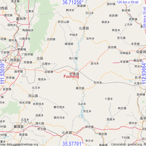
| Upper-left | 36.71256°, | 111.53039° |
| Center: | 36.14684°, | 112.23351° |
| Lower-right: | 35.57701°, | 112.93664° |
| Map W x H: | 126.3×126.3 km | = 78.5×78.5mi |
| max Lat: | 53.31946° ⇑22.4% North |
| Fucheng: | 36.14684° |
| min Lat: | ⇓77.6% South 18.22056° |
| min Long | Fucheng | max Long |
| 75.07348° | 112.23351° | 134.28917° |
| W 38.6%⇐ | ⇒61.4% E |
Elevation
Elevation of Fucheng is 938 m = 3077 ft, and this is 453.2 m = 1487 ft above average elevation for this country.
| Max E: |
5622 m = 18445 ft | 15.7% |
| Fucheng | 938 m 3077 ft | |
| Avg. | 484.8 m = 1591 ft | |
Min E: |
-3 m = -10 ft | 84.3% |
See also: China elevation on elevation.city.
Geographical zone
Fucheng is located in North temperate zone (between Tropic of Cancer and the Arctic Circle). Distance of this Northern Tropic circle is 1413.2 km =878.1 mi to South.| Distance of | km | miles | from Fucheng |
|---|---|---|---|
| North Pole | 5987.9 | 3720.7 | to North |
| Arctic Circle | 3382 | 2101.5 | to North |
| Tropic Cancer | 1413.2 | 878.1 | to South |
| Equator | 4019.2 | 2497.4 | to South |


Nearby cities:
15 places around Fucheng: (largest is in red/bold)
• Dadeng
67.7 km =42.1 mi,  248°
248°
• Dahuaishu
51.8 km =32.2 mi,  284°
284°
• Danzhu
56.4 km =35 mi,  92°
92°
• Dengzhuang
67.1 km =41.7 mi, 252°
• Handian
73.7 km =45.8 mi,  98°
98°
• Linfen
64.5 km =40.1 mi,  264°
264°
• Linjiang
61.5 km =38.2 mi,  70°
70°
• Longgang
51.3 km =31.9 mi,  187°
187°
• Qinhe
40.3 km =25 mi,  11°
11°
• Tangxing
65.7 km =40.8 mi,  227°
227°
• Taosi
71.7 km =44.6 mi, 247°
• Tiantan
40.6 km =25.2 mi,  240°
240°
• Xinzhi
61.5 km =38.2 mi,  309°
309°
• Yangcheng
74.4 km =46.2 mi,  168°
168°
• Yueyang
32.7 km =20.3 mi,  299°
299°
Sources, notices
• [Note1] Compared only with cities in China existing in our database
• [Src1] Map data: © OpenStreetMap contributors (CC-BY-SA)
• [Src2] Other city data from geonames.org with taken over terms of usage.
• [Src3] Geographical zone / Annual Mean Temperature by Robert A. Rohde @ Wikipedia
