Chaoyang geodata
Chaoyang (Hunan) is a seat of a fourth-order administrative division; located in China in Asia/Shanghai (GMT+8) time zone. In our database, there are 1268 cities with bigger population. Compared to other cities in China, 61.5% of cities are located further ↑North; 66.9% of cities are located further →East and 52.8% of cities have lower elevation than Chaoyang. Note1


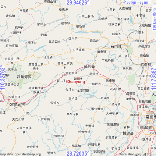
Chaoyang GPS coordinates[2]
29° 20' 6.54" North, 111° 1' 50.664" East
| Map corner | latitude | longitude |
|---|---|---|
| Upper-left | 29.94626°, | 110.32762° |
| Center: | 29.33515°, | 111.03074° |
| Lower-right: | 28.72035°, | 111.73387° |
| Map W x H: | 136.3×136.3 km | = 84.7×84.7mi |
| max Lat: | 53.31946° ⇑61.5% North |
| Chaoyang: | 29.33515° |
| min Lat: | ⇓38.5% South 18.22056° |
| min Long | Chaoyang | max Long |
| 75.07348° | 111.03074° | 134.28917° |
| W 33.1%⇐ | ⇒66.9% E |
Elevation
Elevation of Chaoyang is 187 m = 614 ft, and this is 297.8 m = 977 ft below average elevation for this country.
| Max E: |
5622 m = 18445 ft | 47.2% |
| Avg. | 484.8 m = 1591 ft | |
| Chaoyang | 187 m = 614 ft | |
Min E: |
-3 m = -10 ft | 52.8% |
See also: China elevation on elevation.city.
Geographical zone
Chaoyang is located in North temperate zone (between Tropic of Cancer and the Arctic Circle). Distance of this Northern Tropic circle is 655.8 km =407.5 mi to South.| Distance of | km | miles | from Chaoyang |
|---|---|---|---|
| North Pole | 6745.3 | 4191.3 | to North |
| Arctic Circle | 4139.4 | 2572.1 | to North |
| Tropic Cancer | 655.8 | 407.5 | to South |
| Equator | 3261.8 | 2026.8 | to South |


Nearby cities:
15 places around Chaoyang: (largest is in red/bold)
• Cili
13.2 km =8.2 mi,  41°
41°
• Erfangping
16.7 km =10.4 mi,  108°
108°
• Gaofeng
15.8 km =9.8 mi,  315°
315°
• Gaoqiao
18.3 km =11.4 mi,  193°
193°
• Haoping
24.3 km =15.1 mi, 105°
• Huangshi
23.3 km =14.5 mi,  136°
136°
• Jinglongqiao
7.3 km =4.5 mi,  118°
118°
• Jinping
12 km =7.5 mi,  215°
215°
• Lingxi
14.4 km =8.9 mi,  74°
74°
• Longtanhe
11.1 km =6.9 mi,  156°
156°
• Nanshanping
13.4 km =8.3 mi,  261°
261°
• Shanmuqiao
24.5 km =15.2 mi,  337°
337°
• Tongjinpu
23.4 km =14.5 mi, 344°
• Yanbodu
7.5 km =4.7 mi,  305°
305°
• Yichongqiao
16.4 km =10.2 mi,  268°
268°
Sources, notices
• [Note1] Compared only with cities in China existing in our database
• [Src1] Map data: © OpenStreetMap contributors (CC-BY-SA)
• [Src2] Other city data from geonames.org with taken over terms of usage.
• [Src3] Geographical zone / Annual Mean Temperature by Robert A. Rohde @ Wikipedia
