Tingjiang geodata
Tingjiang (Fujian) is a seat of a fourth-order administrative division; located in China in Asia/Shanghai (GMT+8) time zone. With population of 5,320 people, there are 862 cities with bigger population in this country. Compared to other cities in China, 82.1% of cities are located further ↑North; 78.8% of cities are located further ←West and 87.7% of cities have higher elevation than Tingjiang. Note1


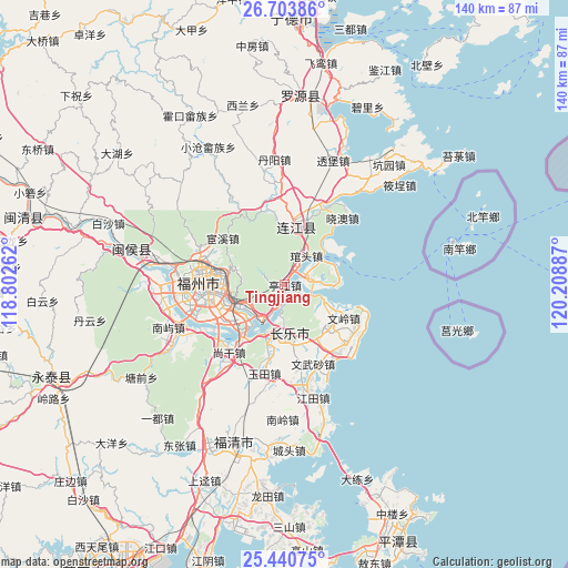
Tingjiang GPS coordinates[2]
26° 4' 26.436" North, 119° 30' 20.664" East
| Map corner | latitude | longitude |
|---|---|---|
| Upper-left | 26.70386°, | 118.80262° |
| Center: | 26.07401°, | 119.50574° |
| Lower-right: | 25.44075°, | 120.20887° |
| Map W x H: | 140.4×140.4 km | = 87.2×87.2mi |
| max Lat: | 53.31946° ⇑82.1% North |
| Tingjiang: | 26.07401° |
| min Lat: | ⇓17.9% South 18.22056° |
| min Long | Tingjiang | max Long |
| 75.07348° | 119.50574° | 134.28917° |
| W 78.8%⇐ | ⇒21.2% E |
Elevation
Elevation of Tingjiang is 12 m = 39 ft, and this is 472.8 m = 1551 ft below average elevation for this country.
| Max E: |
5622 m = 18445 ft | 87.7% |
| Avg. | 484.8 m = 1591 ft | |
| Tingjiang | 12 m = 39 ft | |
Min E: |
-3 m = -10 ft | 12.3% |
See also: China elevation on elevation.city.
Geographical zone
Tingjiang is located in North temperate zone (between Tropic of Cancer and the Arctic Circle). Distance of this Northern Tropic circle is 293.2 km =182.2 mi to South.| Distance of | km | miles | from Tingjiang |
|---|---|---|---|
| North Pole | 7107.9 | 4416.6 | to North |
| Arctic Circle | 4502 | 2797.4 | to North |
| Tropic Cancer | 293.2 | 182.2 | to South |
| Equator | 2899.2 | 1801.5 | to South |


Nearby cities:
15 places around Tingjiang: (largest is in red/bold)
• Aojiang
14.5 km =9 mi,  11°
11°
• Fengcheng
14.1 km =8.8 mi, 13°
• Guantou
8.9 km =5.5 mi,  39°
39°
• Guling
11.6 km =7.2 mi,  280°
280°
• Gushan
16.2 km =10.1 mi,  269°
269°
• Heshang
14.4 km =8.9 mi,  162°
162°
• Houyu
3.3 km =2.1 mi,  118°
118°
• Jiangnan
13.7 km =8.5 mi, 13°
• Jinfeng
15.8 km =9.8 mi,  132°
132°
• Kuai’an
10 km =6.2 mi,  243°
243°
• Langqi
6.8 km =4.2 mi,  75°
75°
• Min’an
2.8 km =1.7 mi,  192°
192°
• Shouzhan
15.3 km =9.5 mi, 189°
• Tantou
10.4 km =6.5 mi, 117°
• Yingqian
12.6 km =7.8 mi,  199°
199°
Sources, notices
• [Note1] Compared only with cities in China existing in our database
• [Src1] Map data: © OpenStreetMap contributors (CC-BY-SA)
• [Src2] Other city data from geonames.org with taken over terms of usage.
• [Src3] Geographical zone / Annual Mean Temperature by Robert A. Rohde @ Wikipedia
