Tantou geodata
Tantou (Fujian) is a seat of a fourth-order administrative division; located in China in Asia/Shanghai (GMT+8) time zone. With population of 69,050 people, there are 619 cities with bigger population in this country. Compared to other cities in China, 82.3% of cities are located further ↑North; 79.4% of cities are located further ←West and 89.9% of cities have higher elevation than Tantou. Note1


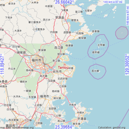
Tantou GPS coordinates[2]
26° 1' 49.188" North, 119° 35' 50.604" East
| Map corner | latitude | longitude |
|---|---|---|
| Upper-left | 26.66042°, | 118.89427° |
| Center: | 26.03033°, | 119.59739° |
| Lower-right: | 25.39684°, | 120.30052° |
| Map W x H: | 140.5×140.5 km | = 87.3×87.3mi |
| max Lat: | 53.31946° ⇑82.3% North |
| Tantou: | 26.03033° |
| min Lat: | ⇓17.7% South 18.22056° |
| min Long | Tantou | max Long |
| 75.07348° | 119.59739° | 134.28917° |
| W 79.4%⇐ | ⇒20.6% E |
Elevation
Elevation of Tantou is 10 m = 33 ft, and this is 474.8 m = 1558 ft below average elevation for this country.
| Max E: |
5622 m = 18445 ft | 89.9% |
| Avg. | 484.8 m = 1591 ft | |
| Tantou | 10 m = 33 ft | |
Min E: |
-3 m = -10 ft | 10.1% |
See also: Tantou elevation on elevation.city.
Geographical zone
Tantou is located in North temperate zone (between Tropic of Cancer and the Arctic Circle). Distance of this Northern Tropic circle is 288.4 km =179.2 mi to South.| Distance of | km | miles | from Tantou |
|---|---|---|---|
| North Pole | 7112.8 | 4419.7 | to North |
| Arctic Circle | 4506.9 | 2800.5 | to North |
| Tropic Cancer | 288.4 | 179.2 | to South |
| Equator | 2894.3 | 1798.4 | to South |


Nearby cities:
15 places around Tantou: (largest is in red/bold)
• Guantou
12.3 km =7.6 mi,  343°
343°
• Guhuai
17.3 km =10.7 mi,  200°
200°
• Heshang
10.2 km =6.3 mi,  208°
208°
• Houyu
7 km =4.3 mi,  297°
297°
• Hunan
8.1 km =5 mi,  143°
143°
• Jinfeng
6.3 km =3.9 mi,  155°
155°
• Kuai’an
18.1 km =11.2 mi,  271°
271°
• Langqi
7 km =4.3 mi, 338°
• Min’an
10 km =6.2 mi,  282°
282°
• Shouzhan
15.6 km =9.7 mi,  228°
228°
• Tingjiang
10.4 km =6.5 mi, 297°
• Wenling
6.4 km =4 mi,  125°
125°
• Wenwusha
14.8 km =9.2 mi,  188°
188°
• Yingqian
15.1 km =9.4 mi,  242°
242°
• Zhanggang
12.1 km =7.5 mi,  165°
165°
Sources, notices
• [Note1] Compared only with cities in China existing in our database
• [Src1] Map data: © OpenStreetMap contributors (CC-BY-SA)
• [Src2] Other city data from geonames.org with taken over terms of usage.
• [Src3] Geographical zone / Annual Mean Temperature by Robert A. Rohde @ Wikipedia
