Min’an geodata
Min’an (Fujian) is a populated place; located in China in Asia/Shanghai (GMT+8) time zone. With population of 5,000 people, there are 872 cities with bigger population in this country. Compared to other cities in China, 82.2% of cities are located further ↑North; 78.8% of cities are located further ←West and 86.9% of cities have higher elevation than Min’an. Note1


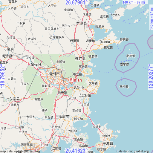
Min’an GPS coordinates[2]
26° 2' 58.632" North, 119° 29' 58.704" East
| Map corner | latitude | longitude |
|---|---|---|
| Upper-left | 26.67961°, | 118.79652° |
| Center: | 26.04962°, | 119.49964° |
| Lower-right: | 25.41623°, | 120.20277° |
| Map W x H: | 140.5×140.5 km | = 87.3×87.3mi |
| max Lat: | 53.31946° ⇑82.2% North |
| Min’an: | 26.04962° |
| min Lat: | ⇓17.8% South 18.22056° |
| min Long | Min’an | max Long |
| 75.07348° | 119.49964° | 134.28917° |
| W 78.8%⇐ | ⇒21.2% E |
Elevation
Elevation of Min’an is 13 m = 43 ft, and this is 471.8 m = 1548 ft below average elevation for this country.
| Max E: |
5622 m = 18445 ft | 86.9% |
| Avg. | 484.8 m = 1591 ft | |
| Min’an | 13 m = 43 ft | |
Min E: |
-3 m = -10 ft | 13.1% |
See also: China elevation on elevation.city.
Geographical zone
Min’an is located in North temperate zone (between Tropic of Cancer and the Arctic Circle). Distance of this Northern Tropic circle is 290.5 km =180.5 mi to South.| Distance of | km | miles | from Min’an |
|---|---|---|---|
| North Pole | 7110.6 | 4418.3 | to North |
| Arctic Circle | 4504.7 | 2799.1 | to North |
| Tropic Cancer | 290.5 | 180.5 | to South |
| Equator | 2896.4 | 1799.7 | to South |


Nearby cities:
15 places around Min’an: (largest is in red/bold)
• Chengmen
15.2 km =9.4 mi,  245°
245°
• Guantou
11.4 km =7.1 mi,  32°
32°
• Guling
11.8 km =7.3 mi,  293°
293°
• Gushan
15.8 km =9.8 mi,  279°
279°
• Heshang
12.1 km =7.5 mi,  156°
156°
• Houyu
3.7 km =2.3 mi,  72°
72°
• Jinfeng
14.6 km =9.1 mi,  122°
122°
• Kuai’an
8.5 km =5.3 mi,  258°
258°
• Langqi
8.4 km =5.2 mi,  58°
58°
• Minjiang
14.9 km =9.3 mi,  226°
226°
• Shouzhan
12.5 km =7.8 mi,  189°
189°
• Tantou
10 km =6.2 mi,  102°
102°
• Tingjiang
2.8 km =1.7 mi,  12°
12°
• Wenling
16.1 km =10 mi,  111°
111°
• Yingqian
9.9 km =6.2 mi,  201°
201°
Sources, notices
• [Note1] Compared only with cities in China existing in our database
• [Src1] Map data: © OpenStreetMap contributors (CC-BY-SA)
• [Src2] Other city data from geonames.org with taken over terms of usage.
• [Src3] Geographical zone / Annual Mean Temperature by Robert A. Rohde @ Wikipedia
