Guanshui geodata
Guanshui (Shandong) is a seat of a fourth-order administrative division; located in China in Asia/Shanghai (GMT+8) time zone. In our database, there are 1268 cities with bigger population. Compared to other cities in China, 79.6% of cities are located further ↓South; 88.9% of cities are located further ←West and 65.8% of cities have higher elevation than Guanshui. Note1


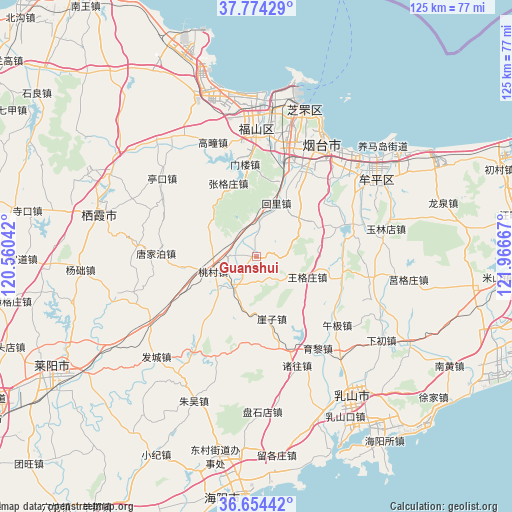
Guanshui GPS coordinates[2]
37° 12' 59.148" North, 121° 15' 48.744" East
| Map corner | latitude | longitude |
|---|---|---|
| Upper-left | 37.77429°, | 120.56042° |
| Center: | 37.21643°, | 121.26354° |
| Lower-right: | 36.65442°, | 121.96667° |
| Map W x H: | 124.5×124.5 km | = 77.4×77.4mi |
| max Lat: | 53.31946° ⇑20.4% North |
| Guanshui: | 37.21643° |
| min Lat: | ⇓79.6% South 18.22056° |
| min Long | Guanshui | max Long |
| 75.07348° | 121.26354° | 134.28917° |
| W 88.9%⇐ | ⇒11.1% E |
Elevation
Elevation of Guanshui is 69 m = 226 ft, and this is 415.8 m = 1364 ft below average elevation for this country.
| Max E: |
5622 m = 18445 ft | 65.8% |
| Avg. | 484.8 m = 1591 ft | |
| Guanshui | 69 m = 226 ft | |
Min E: |
-3 m = -10 ft | 34.2% |
See also: China elevation on elevation.city.
Geographical zone
Guanshui is located in North temperate zone (between Tropic of Cancer and the Arctic Circle). Distance of this Northern Tropic circle is 1532.2 km =952.1 mi to South.| Distance of | km | miles | from Guanshui |
|---|---|---|---|
| North Pole | 5869 | 3646.8 | to North |
| Arctic Circle | 3263.1 | 2027.6 | to North |
| Tropic Cancer | 1532.2 | 952.1 | to South |
| Equator | 4138.1 | 2571.3 | to South |


Nearby cities:
15 places around Guanshui: (largest is in red/bold)
• Binhailu
29 km =18 mi,  30°
30°
• Gaoling
24.5 km =15.2 mi,  69°
69°
• Gaotuan
29.7 km =18.5 mi,  339°
339°
• Huili
13.8 km =8.6 mi,  20°
20°
• Jiejiazhuang
27.9 km =17.3 mi,  45°
45°
• Laishan
22.1 km =13.7 mi, 27°
• Menlou
22.5 km =14 mi,  352°
352°
• Qingyang
31.1 km =19.3 mi,  359°
359°
• Shuidao
28.3 km =17.6 mi,  100°
100°
• Tangjiapo
24.5 km =15.2 mi,  271°
271°
• Wanggezhuang
13.3 km =8.3 mi,  112°
112°
• Wuji
25.7 km =16 mi,  130°
130°
• Wuning
30.9 km =19.2 mi,  56°
56°
• Xujiadian
28.9 km =18 mi,  238°
238°
• Zhanggezhuang
18.9 km =11.7 mi, 338°
Sources, notices
• [Note1] Compared only with cities in China existing in our database
• [Src1] Map data: © OpenStreetMap contributors (CC-BY-SA)
• [Src2] Other city data from geonames.org with taken over terms of usage.
• [Src3] Geographical zone / Annual Mean Temperature by Robert A. Rohde @ Wikipedia
