Wangfu geodata
Wangfu (Zhejiang) is a seat of a fourth-order administrative division; located in China in Asia/Shanghai (GMT+8) time zone. In our database, there are 1268 cities with bigger population. Compared to other cities in China, 55.8% of cities are located further ↑North; 75.6% of cities are located further ←West and 73.5% of cities have lower elevation than Wangfu. Note1


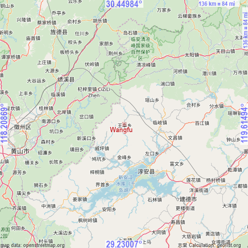
Wangfu GPS coordinates[2]
29° 50' 30.552" North, 118° 54' 42.516" East
| Map corner | latitude | longitude |
|---|---|---|
| Upper-left | 30.44984°, | 118.20869° |
| Center: | 29.84182°, | 118.91181° |
| Lower-right: | 29.23007°, | 119.61494° |
| Map W x H: | 135.6×135.6 km | = 84.3×84.3mi |
| max Lat: | 53.31946° ⇑55.8% North |
| Wangfu: | 29.84182° |
| min Lat: | ⇓44.2% South 18.22056° |
| min Long | Wangfu | max Long |
| 75.07348° | 118.91181° | 134.28917° |
| W 75.6%⇐ | ⇒24.4% E |
Elevation
Elevation of Wangfu is 485 m = 1591 ft, and this is 0.19999999999999 m = 1 ft above average elevation for this country.
| Max E: |
5622 m = 18445 ft | 26.5% |
| Wangfu | 485 m 1591 ft | |
| Avg. | 484.8 m = 1591 ft | |
Min E: |
-3 m = -10 ft | 73.5% |
See also: China elevation on elevation.city.
Geographical zone
Wangfu is located in North temperate zone (between Tropic of Cancer and the Arctic Circle). Distance of this Northern Tropic circle is 712.2 km =442.5 mi to South.| Distance of | km | miles | from Wangfu |
|---|---|---|---|
| North Pole | 6689 | 4156.4 | to North |
| Arctic Circle | 4083.1 | 2537.1 | to North |
| Tropic Cancer | 712.2 | 442.5 | to South |
| Equator | 3318.1 | 2061.8 | to South |


Nearby cities:
15 places around Wangfu: (largest is in red/bold)
• Chakou
20.6 km =12.8 mi,  284°
284°
• Dashe
7.4 km =4.6 mi,  356°
356°
• Jinchuan
16.5 km =10.3 mi,  337°
337°
• Linqi
19.7 km =12.2 mi,  86°
86°
• Sanyang
23.7 km =14.7 mi,  328°
328°
• Songcun
13 km =8.1 mi,  184°
184°
• Tangban
17.6 km =10.9 mi, 179°
• Tangcun
7.3 km =4.5 mi,  236°
236°
• Wangzhai
18.7 km =11.6 mi,  148°
148°
• Weiping
17.7 km =11 mi,  223°
223°
• Xinmen
20.7 km =12.9 mi, 241°
• Xinxikou
21.5 km =13.4 mi,  250°
250°
• Yaoshan
20.2 km =12.6 mi,  47°
47°
• Zhupu
23.1 km =14.4 mi, 340°
• Zuokou
17.8 km =11.1 mi,  133°
133°
Sources, notices
• [Note1] Compared only with cities in China existing in our database
• [Src1] Map data: © OpenStreetMap contributors (CC-BY-SA)
• [Src2] Other city data from geonames.org with taken over terms of usage.
• [Src3] Geographical zone / Annual Mean Temperature by Robert A. Rohde @ Wikipedia
