Songcun geodata
Songcun (Zhejiang) is a seat of a fourth-order administrative division; located in China in Asia/Shanghai (GMT+8) time zone. In our database, there are 1268 cities with bigger population. Compared to other cities in China, 57.1% of cities are located further ↑North; 75.5% of cities are located further ←West and 51.1% of cities have lower elevation than Songcun. Note1


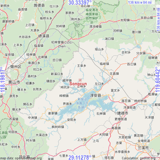
Songcun GPS coordinates[2]
29° 43' 30.828" North, 118° 54' 4.644" East
| Map corner | latitude | longitude |
|---|---|---|
| Upper-left | 30.33397°, | 118.19817° |
| Center: | 29.72523°, | 118.90129° |
| Lower-right: | 29.11278°, | 119.60442° |
| Map W x H: | 135.8×135.8 km | = 84.4×84.4mi |
| max Lat: | 53.31946° ⇑57.1% North |
| Songcun: | 29.72523° |
| min Lat: | ⇓42.9% South 18.22056° |
| min Long | Songcun | max Long |
| 75.07348° | 118.90129° | 134.28917° |
| W 75.5%⇐ | ⇒24.5% E |
Elevation
Elevation of Songcun is 174 m = 571 ft, and this is 310.8 m = 1020 ft below average elevation for this country.
| Max E: |
5622 m = 18445 ft | 48.9% |
| Avg. | 484.8 m = 1591 ft | |
| Songcun | 174 m = 571 ft | |
Min E: |
-3 m = -10 ft | 51.1% |
See also: China elevation on elevation.city.
Geographical zone
Songcun is located in North temperate zone (between Tropic of Cancer and the Arctic Circle). Distance of this Northern Tropic circle is 699.2 km =434.5 mi to South.| Distance of | km | miles | from Songcun |
|---|---|---|---|
| North Pole | 6701.9 | 4164.4 | to North |
| Arctic Circle | 4096 | 2545.1 | to North |
| Tropic Cancer | 699.2 | 434.5 | to South |
| Equator | 3305.1 | 2053.7 | to South |


Nearby cities:
15 places around Songcun: (largest is in red/bold)
• Dashe
20.3 km =12.6 mi,  1°
1°
• Dujing
19.7 km =12.2 mi,  225°
225°
• Huangtian
24.9 km =15.5 mi,  268°
268°
• Jiukeng
16 km =9.9 mi,  251°
251°
• Linqi
25.1 km =15.6 mi,  55°
55°
• Tangban
4.8 km =3 mi,  164°
164°
• Tangcun
10.3 km =6.4 mi,  330°
330°
• Tongziwu
19.6 km =12.2 mi,  196°
196°
• Wangfu
13 km =8.1 mi, 4°
• Wangzhai
11.2 km =7 mi,  105°
105°
• Weiping
11.3 km =7 mi, 270°
• Xinmen
17.4 km =10.8 mi,  279°
279°
• Xinxikou
20.1 km =12.5 mi,  286°
286°
• Yaojia
22.3 km =13.9 mi,  210°
210°
• Zuokou
13.9 km =8.6 mi,  87°
87°
Sources, notices
• [Note1] Compared only with cities in China existing in our database
• [Src1] Map data: © OpenStreetMap contributors (CC-BY-SA)
• [Src2] Other city data from geonames.org with taken over terms of usage.
• [Src3] Geographical zone / Annual Mean Temperature by Robert A. Rohde @ Wikipedia
