Weiping geodata
Weiping (Zhejiang) is a seat of a fourth-order administrative division; located in China in Asia/Shanghai (GMT+8) time zone. In our database, there are 1268 cities with bigger population. Compared to other cities in China, 57.1% of cities are located further ↑North; 74.9% of cities are located further ←West and 50.8% of cities have lower elevation than Weiping. Note1


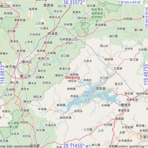
Weiping GPS coordinates[2]
29° 43' 37.164" North, 118° 47' 3.912" East
| Map corner | latitude | longitude |
|---|---|---|
| Upper-left | 30.33572°, | 118.0813° |
| Center: | 29.72699°, | 118.78442° |
| Lower-right: | 29.11455°, | 119.48755° |
| Map W x H: | 135.8×135.8 km | = 84.4×84.4mi |
| max Lat: | 53.31946° ⇑57.1% North |
| Weiping: | 29.72699° |
| min Lat: | ⇓42.9% South 18.22056° |
| min Long | Weiping | max Long |
| 75.07348° | 118.78442° | 134.28917° |
| W 74.9%⇐ | ⇒25.1% E |
Elevation
Elevation of Weiping is 172 m = 564 ft, and this is 312.8 m = 1026 ft below average elevation for this country.
| Max E: |
5622 m = 18445 ft | 49.2% |
| Avg. | 484.8 m = 1591 ft | |
| Weiping | 172 m = 564 ft | |
Min E: |
-3 m = -10 ft | 50.8% |
See also: China elevation on elevation.city.
Geographical zone
Weiping is located in North temperate zone (between Tropic of Cancer and the Arctic Circle). Distance of this Northern Tropic circle is 699.4 km =434.6 mi to South.| Distance of | km | miles | from Weiping |
|---|---|---|---|
| North Pole | 6701.7 | 4164.2 | to North |
| Arctic Circle | 4095.8 | 2545 | to North |
| Tropic Cancer | 699.4 | 434.6 | to South |
| Equator | 3305.3 | 2053.8 | to South |


Nearby cities:
15 places around Weiping: (largest is in red/bold)
• Chakou
19.5 km =12.1 mi,  337°
337°
• Dujing
14.2 km =8.8 mi,  191°
191°
• Huangtian
13.6 km =8.5 mi,  266°
266°
• Huangwei
14.6 km =9.1 mi,  253°
253°
• Jiukeng
6.5 km =4 mi,  217°
217°
• Songcun
11.3 km =7 mi,  90°
90°
• Tangban
13.4 km =8.3 mi,  110°
110°
• Tangcun
10.8 km =6.7 mi,  35°
35°
• Tongziwu
19.9 km =12.4 mi,  162°
162°
• Wangfu
17.7 km =11 mi, 43°
• Wuyang
18.5 km =11.5 mi,  316°
316°
• Xiaochuan
15.6 km =9.7 mi,  306°
306°
• Xinmen
6.5 km =4 mi,  295°
295°
• Xinxikou
9.8 km =6.1 mi, 305°
• Yaojia
19.4 km =12.1 mi,  180°
180°
Sources, notices
• [Note1] Compared only with cities in China existing in our database
• [Src1] Map data: © OpenStreetMap contributors (CC-BY-SA)
• [Src2] Other city data from geonames.org with taken over terms of usage.
• [Src3] Geographical zone / Annual Mean Temperature by Robert A. Rohde @ Wikipedia
