Songmuping geodata
Songmuping (Hubei) is a seat of a fourth-order administrative division; located in China in Asia/Shanghai (GMT+8) time zone. In our database, there are 1268 cities with bigger population. Compared to other cities in China, 52.7% of cities are located further ↑North; 65.1% of cities are located further →East and 59.1% of cities have lower elevation than Songmuping. Note1


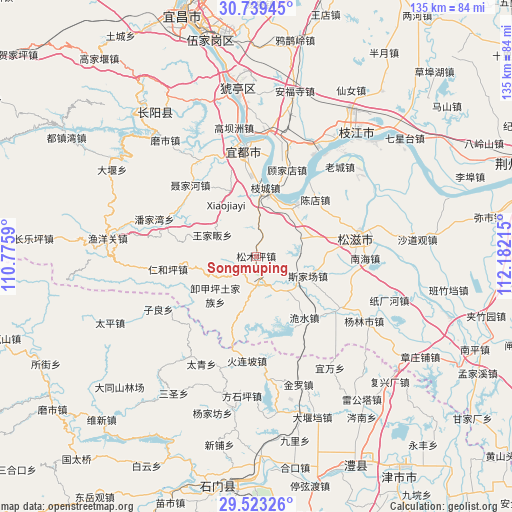
Songmuping GPS coordinates[2]
30° 7' 59.628" North, 111° 28' 44.472" East
| Map corner | latitude | longitude |
|---|---|---|
| Upper-left | 30.73945°, | 110.7759° |
| Center: | 30.13323°, | 111.47902° |
| Lower-right: | 29.52326°, | 112.18215° |
| Map W x H: | 135.2×135.2 km | = 84×84mi |
| max Lat: | 53.31946° ⇑52.7% North |
| Songmuping: | 30.13323° |
| min Lat: | ⇓47.3% South 18.22056° |
| min Long | Songmuping | max Long |
| 75.07348° | 111.47902° | 134.28917° |
| W 34.9%⇐ | ⇒65.1% E |
Elevation
Elevation of Songmuping is 248 m = 814 ft, and this is 236.8 m = 777 ft below average elevation for this country.
| Max E: |
5622 m = 18445 ft | 40.9% |
| Avg. | 484.8 m = 1591 ft | |
| Songmuping | 248 m = 814 ft | |
Min E: |
-3 m = -10 ft | 59.1% |
See also: China elevation on elevation.city.
Geographical zone
Songmuping is located in North temperate zone (between Tropic of Cancer and the Arctic Circle). Distance of this Northern Tropic circle is 744.6 km =462.7 mi to South.| Distance of | km | miles | from Songmuping |
|---|---|---|---|
| North Pole | 6656.6 | 4136.2 | to North |
| Arctic Circle | 4050.7 | 2517 | to North |
| Tropic Cancer | 744.6 | 462.7 | to South |
| Equator | 3350.5 | 2081.9 | to South |


Nearby cities:
15 places around Songmuping: (largest is in red/bold)
• Chendian
21.6 km =13.4 mi,  46°
46°
• Gujiadian
23.9 km =14.9 mi,  23°
23°
• Huolianpo
27.9 km =17.3 mi,  185°
185°
• Jieheshi
26.3 km =16.3 mi,  120°
120°
• Liujiachang
8.1 km =5 mi, 185°
• Niejiahe
26 km =16.2 mi,  317°
317°
• Renheping
23.6 km =14.7 mi,  261°
261°
• Sijiachang
14.7 km =9.1 mi,  111°
111°
• Wangjiafan
12.7 km =7.9 mi,  295°
295°
• Wangjiaqiao
18.5 km =11.5 mi,  89°
89°
• Wanjia
27.7 km =17.2 mi,  131°
131°
• Weishui
20.7 km =12.9 mi,  141°
141°
• Xiejiaping
15 km =9.3 mi,  226°
226°
• Yaojiadian
26.3 km =16.3 mi,  351°
351°
• Zhicheng
18.2 km =11.3 mi,  7°
7°
Sources, notices
• [Note1] Compared only with cities in China existing in our database
• [Src1] Map data: © OpenStreetMap contributors (CC-BY-SA)
• [Src2] Other city data from geonames.org with taken over terms of usage.
• [Src3] Geographical zone / Annual Mean Temperature by Robert A. Rohde @ Wikipedia
