Songkou geodata
Songkou (Fujian) is a seat of a fourth-order administrative division; located in China in Asia/Shanghai (GMT+8) time zone. In our database, there are 1268 cities with bigger population. Compared to other cities in China, 81.7% of cities are located further ↑North; 65.4% of cities are located further ←West and 61.6% of cities have lower elevation than Songkou. Note1


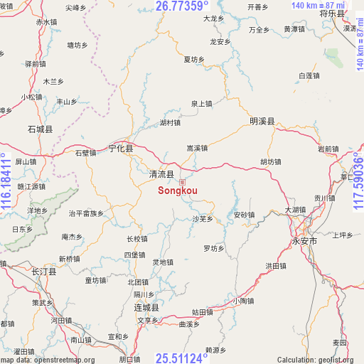
Songkou GPS coordinates[2]
26° 8' 38.832" North, 116° 53' 14.028" East
| Map corner | latitude | longitude |
|---|---|---|
| Upper-left | 26.77359°, | 116.18411° |
| Center: | 26.14412°, | 116.88723° |
| Lower-right: | 25.51124°, | 117.59036° |
| Map W x H: | 140.4×140.4 km | = 87.2×87.2mi |
| max Lat: | 53.31946° ⇑81.7% North |
| Songkou: | 26.14412° |
| min Lat: | ⇓18.3% South 18.22056° |
| min Long | Songkou | max Long |
| 75.07348° | 116.88723° | 134.28917° |
| W 65.4%⇐ | ⇒34.6% E |
Elevation
Elevation of Songkou is 278 m = 912 ft, and this is 206.8 m = 678 ft below average elevation for this country.
| Max E: |
5622 m = 18445 ft | 38.4% |
| Avg. | 484.8 m = 1591 ft | |
| Songkou | 278 m = 912 ft | |
Min E: |
-3 m = -10 ft | 61.6% |
See also: China elevation on elevation.city.
Geographical zone
Songkou is located in North temperate zone (between Tropic of Cancer and the Arctic Circle). Distance of this Northern Tropic circle is 301 km =187 mi to South.| Distance of | km | miles | from Songkou |
|---|---|---|---|
| North Pole | 7100.1 | 4411.8 | to North |
| Arctic Circle | 4494.2 | 2792.6 | to North |
| Tropic Cancer | 301 | 187 | to South |
| Equator | 2907 | 1806.3 | to South |


Nearby cities:
15 places around Songkou: (largest is in red/bold)
• Ansha
26.8 km =16.7 mi,  117°
117°
• Chengnan
19 km =11.8 mi,  294°
294°
• Dengjia
25.8 km =16 mi,  190°
190°
• Hucun
23.3 km =14.5 mi,  349°
349°
• Laifang
23.1 km =14.4 mi,  180°
180°
• Linshe
26.7 km =16.6 mi,  43°
43°
• Litian
23.6 km =14.7 mi,  232°
232°
• Longjin
8.4 km =5.2 mi,  300°
300°
• Shawu
16.1 km =10 mi,  149°
149°
• Songxi
14.7 km =9.1 mi,  23°
23°
• Tianyuan
10.8 km =6.7 mi,  202°
202°
• Xianan
26.5 km =16.5 mi, 300°
• Xiaochi
16.4 km =10.2 mi,  52°
52°
• Xinggongxia
15.7 km =9.8 mi,  256°
256°
• Yupeng
16.1 km =10 mi,  107°
107°
Sources, notices
• [Note1] Compared only with cities in China existing in our database
• [Src1] Map data: © OpenStreetMap contributors (CC-BY-SA)
• [Src2] Other city data from geonames.org with taken over terms of usage.
• [Src3] Geographical zone / Annual Mean Temperature by Robert A. Rohde @ Wikipedia
