Humen geodata
Humen (Guangdong) is a seat of a fourth-order administrative division; located in China in Asia/Shanghai (GMT+8) time zone. With population of 191,891 people, there are 236 cities with bigger population in this country. Compared to other cities in China, 95.2% of cities are located further ↑North; 53.2% of cities are located further →East and 82.9% of cities have higher elevation than Humen. Note1


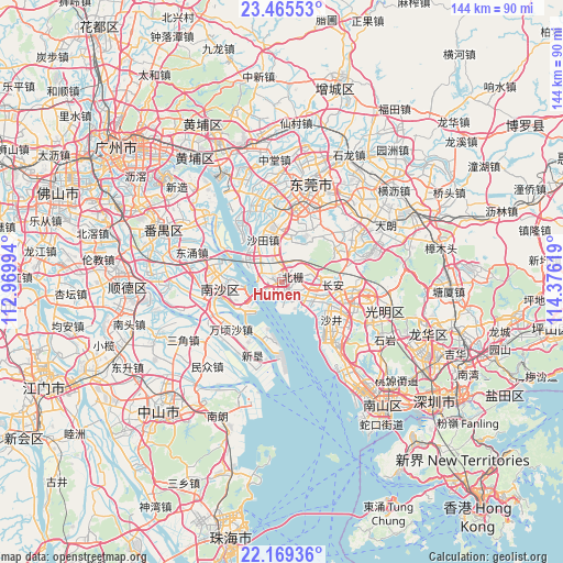
Humen GPS coordinates[2]
22° 49' 8.364" North, 113° 40' 23.016" East
| Map corner | latitude | longitude |
|---|---|---|
| Upper-left | 23.46553°, | 112.96994° |
| Center: | 22.81899°, | 113.67306° |
| Lower-right: | 22.16936°, | 114.37619° |
| Map W x H: | 144.1×144.1 km | = 89.5×89.5mi |
| max Lat: | 53.31946° ⇑95.2% North |
| Humen: | 22.81899° |
| min Lat: | ⇓4.8% South 18.22056° |
| min Long | Humen | max Long |
| 75.07348° | 113.67306° | 134.28917° |
| W 46.8%⇐ | ⇒53.2% E |
Elevation
Elevation of Humen is 20 m = 66 ft, and this is 464.8 m = 1525 ft below average elevation for this country.
| Max E: |
5622 m = 18445 ft | 82.9% |
| Avg. | 484.8 m = 1591 ft | |
| Humen | 20 m = 66 ft | |
Min E: |
-3 m = -10 ft | 17.1% |
See also: Humen elevation on elevation.city.
Geographical zone
Humen is located in North Torrid zone (between Equator and Tropic of Cancer). Distance of this Northern Tropic circle is 68.7 km =42.7 mi to North.| Distance of | km | miles | from Humen |
|---|---|---|---|
| North Pole | 7469.8 | 4641.5 | to North |
| Arctic Circle | 4863.9 | 3022.3 | to North |
| Tropic Cancer | 68.7 | 42.7 | to North |
| Equator | 2537.2 | 1576.5 | to South |


Nearby cities:
15 places around Humen: (largest is in red/bold)
• Chang’an
13.4 km =8.3 mi,  95°
95°
• Daojiao
20.3 km =12.6 mi,  355°
355°
• Dongguan
23.4 km =14.5 mi,  19°
19°
• Fuyong
21.9 km =13.6 mi,  138°
138°
• Gongming
21.7 km =13.5 mi, 99°
• Hengli
21.6 km =13.4 mi,  244°
244°
• Hongmei
20.7 km =12.9 mi,  339°
339°
• Houjie
14.1 km =8.8 mi,  352°
352°
• Huangge
17.1 km =10.6 mi,  273°
273°
• Nansha
10.9 km =6.8 mi,  261°
261°
• Shajing
17 km =10.6 mi,  118°
118°
• Shatian
13.2 km =8.2 mi,  331°
331°
• Songgang
18.2 km =11.3 mi, 104°
• Wanqingsha
18.1 km =11.2 mi,  226°
226°
• Xinwan
3.6 km =2.2 mi,  188°
188°
Sources, notices
• [Note1] Compared only with cities in China existing in our database
• [Src1] Map data: © OpenStreetMap contributors (CC-BY-SA)
• [Src2] Other city data from geonames.org with taken over terms of usage.
• [Src3] Geographical zone / Annual Mean Temperature by Robert A. Rohde @ Wikipedia
