Shuitianzhuang geodata
Shuitianzhuang (Hunan) is a seat of a fourth-order administrative division; located in China in Asia/Shanghai (GMT+8) time zone. In our database, there are 1268 cities with bigger population. Compared to other cities in China, 73.7% of cities are located further ↑North; 67.9% of cities are located further →East and 65.9% of cities have lower elevation than Shuitianzhuang. Note1


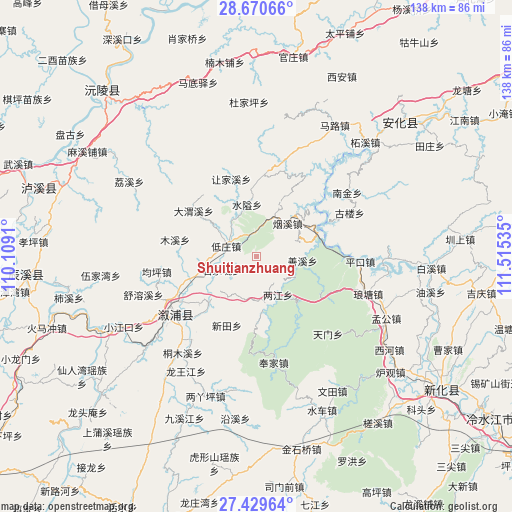
Shuitianzhuang GPS coordinates[2]
28° 3' 6.984" North, 110° 48' 43.992" East
| Map corner | latitude | longitude |
|---|---|---|
| Upper-left | 28.67066°, | 110.1091° |
| Center: | 28.05194°, | 110.81222° |
| Lower-right: | 27.42964°, | 111.51535° |
| Map W x H: | 138×138 km | = 85.7×85.7mi |
| max Lat: | 53.31946° ⇑73.7% North |
| Shuitianzhuang: | 28.05194° |
| min Lat: | ⇓26.3% South 18.22056° |
| min Long | Shuitianzhuang | max Long |
| 75.07348° | 110.81222° | 134.28917° |
| W 32.1%⇐ | ⇒67.9% E |
Elevation
Elevation of Shuitianzhuang is 341 m = 1119 ft, and this is 143.8 m = 472 ft below average elevation for this country.
| Max E: |
5622 m = 18445 ft | 34.1% |
| Avg. | 484.8 m = 1591 ft | |
| Shuitianzhuang | 341 m = 1119 ft | |
Min E: |
-3 m = -10 ft | 65.9% |
See also: China elevation on elevation.city.
Geographical zone
Shuitianzhuang is located in North temperate zone (between Tropic of Cancer and the Arctic Circle). Distance of this Northern Tropic circle is 513.2 km =318.9 mi to South.| Distance of | km | miles | from Shuitianzhuang |
|---|---|---|---|
| North Pole | 6888 | 4280 | to North |
| Arctic Circle | 4282.1 | 2660.8 | to North |
| Tropic Cancer | 513.2 | 318.9 | to South |
| Equator | 3119.1 | 1938.1 | to South |


Nearby cities:
15 places around Shuitianzhuang: (largest is in red/bold)
• Cangchang
37.4 km =23.2 mi,  17°
17°
• Gangdong
15.2 km =9.4 mi,  171°
171°
• Guanyinge
20 km =12.4 mi,  252°
252°
• Gulou
31 km =19.3 mi,  65°
65°
• Kuixi
20.2 km =12.6 mi,  1°
1°
• Langtang
33.4 km =20.8 mi,  98°
98°
• Liangjiang
12.1 km =7.5 mi,  153°
153°
• Liangyaping
39.6 km =24.6 mi,  200°
200°
• Lufeng
27.3 km =17 mi,  234°
234°
• Muxi
22.4 km =13.9 mi,  281°
281°
• Qiaojiang
18.5 km =11.5 mi, 226°
• Shanxi
14.1 km =8.8 mi, 99°
• Tongmuxi
32.8 km =20.4 mi,  217°
217°
• Weixi
32.7 km =20.3 mi,  311°
311°
• Xiaojiangkou
40.7 km =25.3 mi,  242°
242°
Sources, notices
• [Note1] Compared only with cities in China existing in our database
• [Src1] Map data: © OpenStreetMap contributors (CC-BY-SA)
• [Src2] Other city data from geonames.org with taken over terms of usage.
• [Src3] Geographical zone / Annual Mean Temperature by Robert A. Rohde @ Wikipedia
