Lufeng geodata
Lufeng (Hunan) is a seat of a third-order administrative division; located in China in Asia/Shanghai (GMT+8) time zone. In our database, there are 1268 cities with bigger population. Compared to other cities in China, 74.6% of cities are located further ↑North; 68.7% of cities are located further →East and 50.3% of cities have higher elevation than Lufeng. Note1


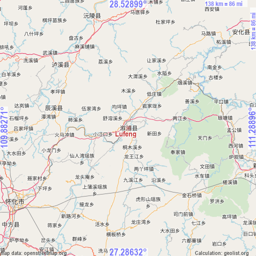
Lufeng GPS coordinates[2]
27° 54' 33.984" North, 110° 35' 8.988" East
| Map corner | latitude | longitude |
|---|---|---|
| Upper-left | 28.52899°, | 109.88271° |
| Center: | 27.90944°, | 110.58583° |
| Lower-right: | 27.28632°, | 111.28896° |
| Map W x H: | 138.2×138.2 km | = 85.9×85.9mi |
| max Lat: | 53.31946° ⇑74.6% North |
| Lufeng: | 27.90944° |
| min Lat: | ⇓25.4% South 18.22056° |
| min Long | Lufeng | max Long |
| 75.07348° | 110.58583° | 134.28917° |
| W 31.3%⇐ | ⇒68.7% E |
Elevation
Elevation of Lufeng is 162 m = 531 ft, and this is 322.8 m = 1059 ft below average elevation for this country.
| Max E: |
5622 m = 18445 ft | 50.3% |
| Avg. | 484.8 m = 1591 ft | |
| Lufeng | 162 m = 531 ft | |
Min E: |
-3 m = -10 ft | 49.7% |
See also: China elevation on elevation.city.
Geographical zone
Lufeng is located in North temperate zone (between Tropic of Cancer and the Arctic Circle). Distance of this Northern Tropic circle is 497.3 km =309 mi to South.| Distance of | km | miles | from Lufeng |
|---|---|---|---|
| North Pole | 6903.8 | 4289.8 | to North |
| Arctic Circle | 4297.9 | 2670.6 | to North |
| Tropic Cancer | 497.3 | 309 | to South |
| Equator | 3103.2 | 1928.2 | to South |


Nearby cities:
15 places around Lufeng: (largest is in red/bold)
• Gangdong
24.4 km =15.2 mi,  88°
88°
• Guanyinge
10.4 km =6.5 mi,  17°
17°
• Huangxikou
29 km =18 mi,  222°
222°
• Jiuxijiang
28.4 km =17.6 mi,  174°
174°
• Liangjiang
28 km =17.4 mi,  79°
79°
• Liangyaping
22.8 km =14.2 mi,  158°
158°
• Muxi
20.3 km =12.6 mi,  0°
0°
• Qiaojiang
9.4 km =5.8 mi,  70°
70°
• Shuitianzhuang
27.3 km =17 mi,  54°
54°
• Tongmuxi
10.5 km =6.5 mi, 166°
• Tongxihe
18.2 km =11.3 mi,  188°
188°
• Xianrenwan
30.5 km =19 mi,  235°
235°
• Xiaojiangkou
14.1 km =8.8 mi,  256°
256°
• Xiuxi
29.6 km =18.4 mi,  284°
284°
• Yongping
33.7 km =20.9 mi,  323°
323°
Sources, notices
• [Note1] Compared only with cities in China existing in our database
• [Src1] Map data: © OpenStreetMap contributors (CC-BY-SA)
• [Src2] Other city data from geonames.org with taken over terms of usage.
• [Src3] Geographical zone / Annual Mean Temperature by Robert A. Rohde @ Wikipedia
