Gangdong geodata
Gangdong (Hunan) is a populated place; located in China in Asia/Shanghai (GMT+8) time zone. With population of 1,380 people, there are 1111 cities with bigger population in this country. Compared to other cities in China, 74.6% of cities are located further ↑North; 67.7% of cities are located further →East and 70.1% of cities have lower elevation than Gangdong. Note1


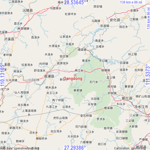
Gangdong GPS coordinates[2]
27° 55' 0.984" North, 110° 50' 3.012" East
| Map corner | latitude | longitude |
|---|---|---|
| Upper-left | 28.53645°, | 110.13105° |
| Center: | 27.91694°, | 110.83417° |
| Lower-right: | 27.29386°, | 111.5373° |
| Map W x H: | 138.2×138.2 km | = 85.9×85.9mi |
| max Lat: | 53.31946° ⇑74.6% North |
| Gangdong: | 27.91694° |
| min Lat: | ⇓25.4% South 18.22056° |
| min Long | Gangdong | max Long |
| 75.07348° | 110.83417° | 134.28917° |
| W 32.3%⇐ | ⇒67.7% E |
Elevation
Elevation of Gangdong is 413 m = 1355 ft, and this is 71.8 m = 236 ft below average elevation for this country.
| Max E: |
5622 m = 18445 ft | 29.9% |
| Avg. | 484.8 m = 1591 ft | |
| Gangdong | 413 m = 1355 ft | |
Min E: |
-3 m = -10 ft | 70.1% |
See also: China elevation on elevation.city.
Geographical zone
Gangdong is located in North temperate zone (between Tropic of Cancer and the Arctic Circle). Distance of this Northern Tropic circle is 498.2 km =309.6 mi to South.| Distance of | km | miles | from Gangdong |
|---|---|---|---|
| North Pole | 6903 | 4289.3 | to North |
| Arctic Circle | 4297.1 | 2670.1 | to North |
| Tropic Cancer | 498.2 | 309.6 | to South |
| Equator | 3104.1 | 1928.8 | to South |


Nearby cities:
15 places around Gangdong: (largest is in red/bold)
• Guanyinge
23.2 km =14.4 mi,  293°
293°
• Jiuxijiang
36.3 km =22.6 mi,  216°
216°
• Kuixi
35.2 km =21.9 mi,  357°
357°
• Langtang
32.4 km =20.1 mi,  72°
72°
• Liangjiang
5.2 km =3.2 mi,  37°
37°
• Liangyaping
27.3 km =17 mi, 216°
• Lufeng
24.4 km =15.2 mi,  268°
268°
• Muxi
31 km =19.3 mi,  308°
308°
• Qiaojiang
15.7 km =9.8 mi,  278°
278°
• Shanxi
17.4 km =10.8 mi, 42°
• Shuiche
30.3 km =18.8 mi,  147°
147°
• Shuitianzhuang
15.2 km =9.4 mi,  351°
351°
• Tongmuxi
24.7 km =15.3 mi,  243°
243°
• Tongxihe
33.1 km =20.6 mi, 235°
• Xixi
27.4 km =17 mi, 154°
Sources, notices
• [Note1] Compared only with cities in China existing in our database
• [Src1] Map data: © OpenStreetMap contributors (CC-BY-SA)
• [Src2] Other city data from geonames.org with taken over terms of usage.
• [Src3] Geographical zone / Annual Mean Temperature by Robert A. Rohde @ Wikipedia
