Cangchang geodata
Cangchang (Hunan) is a seat of a fourth-order administrative division; located in China in Asia/Shanghai (GMT+8) time zone. In our database, there are 1268 cities with bigger population. Compared to other cities in China, 70.9% of cities are located further ↑North; 67.3% of cities are located further →East and 79.8% of cities have lower elevation than Cangchang. Note1


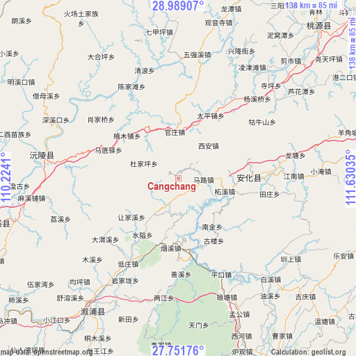
Cangchang GPS coordinates[2]
28° 22' 19.992" North, 110° 55' 37.992" East
| Map corner | latitude | longitude |
|---|---|---|
| Upper-left | 28.98907°, | 110.2241° |
| Center: | 28.37222°, | 110.92722° |
| Lower-right: | 27.75176°, | 111.63035° |
| Map W x H: | 137.6×137.6 km | = 85.5×85.5mi |
| max Lat: | 53.31946° ⇑70.9% North |
| Cangchang: | 28.37222° |
| min Lat: | ⇓29.1% South 18.22056° |
| min Long | Cangchang | max Long |
| 75.07348° | 110.92722° | 134.28917° |
| W 32.7%⇐ | ⇒67.3% E |
Elevation
Elevation of Cangchang is 687 m = 2254 ft, and this is 202.2 m = 663 ft above average elevation for this country.
| Max E: |
5622 m = 18445 ft | 20.2% |
| Cangchang | 687 m 2254 ft | |
| Avg. | 484.8 m = 1591 ft | |
Min E: |
-3 m = -10 ft | 79.8% |
See also: China elevation on elevation.city.
Geographical zone
Cangchang is located in North temperate zone (between Tropic of Cancer and the Arctic Circle). Distance of this Northern Tropic circle is 548.8 km =341 mi to South.| Distance of | km | miles | from Cangchang |
|---|---|---|---|
| North Pole | 6852.4 | 4257.9 | to North |
| Arctic Circle | 4246.5 | 2638.7 | to North |
| Tropic Cancer | 548.8 | 341 | to South |
| Equator | 3154.7 | 1960.2 | to South |


Nearby cities:
15 places around Cangchang: (largest is in red/bold)
• Cha’anpu
36.8 km =22.9 mi,  37°
37°
• Chenjiatan
38.7 km =24 mi,  333°
333°
• Dongping
27.3 km =17 mi,  88°
88°
• Guanzhuang
18.1 km =11.2 mi,  351°
351°
• Gulou
28.4 km =17.6 mi,  143°
143°
• Guniushan
37.9 km =23.5 mi,  59°
59°
• Huangrangping
35.3 km =21.9 mi,  11°
11°
• Kuixi
18.9 km =11.7 mi,  215°
215°
• Langtang
46.2 km =28.7 mi,  151°
151°
• Liangjiang
46.9 km =29.1 mi,  187°
187°
• Muxi
45.5 km =28.3 mi,  226°
226°
• Shanxi
38 km =23.6 mi,  175°
175°
• Shuitianzhuang
37.4 km =23.2 mi,  197°
197°
• Weixi
38.2 km =23.7 mi,  248°
248°
• Xi’an
16 km =9.9 mi,  48°
48°
Sources, notices
• [Note1] Compared only with cities in China existing in our database
• [Src1] Map data: © OpenStreetMap contributors (CC-BY-SA)
• [Src2] Other city data from geonames.org with taken over terms of usage.
• [Src3] Geographical zone / Annual Mean Temperature by Robert A. Rohde @ Wikipedia
