Yilong geodata
Yilong (Yunnan) is a seat of a third-order administrative division; located in China in Asia/Shanghai (GMT+8) time zone. In our database, there are 1268 cities with bigger population. Compared to other cities in China, 91.4% of cities are located further ↑North; 92.3% of cities are located further →East and 90.8% of cities have lower elevation than Yilong. Note1


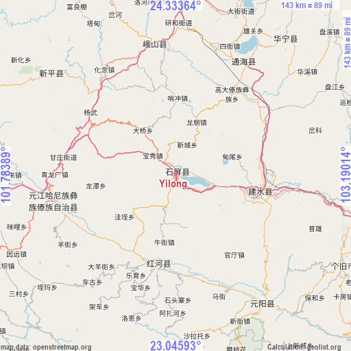
Yilong GPS coordinates[2]
23° 41' 28.932" North, 102° 29' 13.236" East
| Map corner | latitude | longitude |
|---|---|---|
| Upper-left | 24.33364°, | 101.78389° |
| Center: | 23.69137°, | 102.48701° |
| Lower-right: | 23.04593°, | 103.19014° |
| Map W x H: | 143.2×143.2 km | = 89×89mi |
| max Lat: | 53.31946° ⇑91.4% North |
| Yilong: | 23.69137° |
| min Lat: | ⇓8.6% South 18.22056° |
| min Long | Yilong | max Long |
| 75.07348° | 102.48701° | 134.28917° |
| W 7.7%⇐ | ⇒92.3% E |
Elevation
Elevation of Yilong is 1435 m = 4708 ft, and this is 950.2 m = 3117 ft above average elevation for this country.
| Max E: |
5622 m = 18445 ft | 9.2% |
| Yilong | 1435 m 4708 ft | |
| Avg. | 484.8 m = 1591 ft | |
Min E: |
-3 m = -10 ft | 90.8% |
See also: China elevation on elevation.city.
Geographical zone
Yilong is located in North temperate zone (between Tropic of Cancer and the Arctic Circle). Distance of this Northern Tropic circle is 28.3 km =17.6 mi to South.| Distance of | km | miles | from Yilong |
|---|---|---|---|
| North Pole | 7372.8 | 4581.2 | to North |
| Arctic Circle | 4766.9 | 2962 | to North |
| Tropic Cancer | 28.3 | 17.6 | to South |
| Equator | 2634.2 | 1636.8 | to South |


Nearby cities:
15 places around Yilong: (largest is in red/bold)
• Baigecun
54.9 km =34.1 mi,  19°
19°
• Fenghuangshan
51.7 km =32.1 mi,  326°
326°
• Hexi
52.9 km =32.9 mi, 18°
• Jiujie
51.2 km =31.8 mi, 23°
• Lijiang
51 km =31.7 mi,  254°
254°
• Lin’an
36.4 km =22.6 mi,  105°
105°
• Lishan
50.1 km =31.1 mi,  32°
32°
• Longwu
35.6 km =22.1 mi,  345°
345°
• Najiaying
60.3 km =37.5 mi, 25°
• Shuangjiang
54.2 km =33.7 mi, 350°
• Sijie
57.3 km =35.6 mi, 22°
• Xiaojie
52 km =32.3 mi,  357°
357°
• Xiushan
54.3 km =33.7 mi, 30°
• Yangguang
58.6 km =36.4 mi, 32°
• Yisa
40.1 km =24.9 mi,  185°
185°
Sources, notices
• [Note1] Compared only with cities in China existing in our database
• [Src1] Map data: © OpenStreetMap contributors (CC-BY-SA)
• [Src2] Other city data from geonames.org with taken over terms of usage.
• [Src3] Geographical zone / Annual Mean Temperature by Robert A. Rohde @ Wikipedia
