Lijiang geodata
Lijiang (Yunnan) is a seat of a third-order administrative division; located in China in Asia/Shanghai (GMT+8) time zone. In our database, there are 1268 cities with bigger population. Compared to other cities in China, 91.9% of cities are located further ↑North; 92.8% of cities are located further →East and 69.8% of cities have lower elevation than Lijiang. Note1


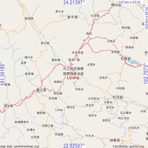
Lijiang GPS coordinates[2]
23° 34' 15.96" North, 102° 0' 15.012" East
| Map corner | latitude | longitude |
|---|---|---|
| Upper-left | 24.21397°, | 101.30105° |
| Center: | 23.5711°, | 102.00417° |
| Lower-right: | 22.92507°, | 102.7073° |
| Map W x H: | 143.3×143.3 km | = 89×89mi |
| max Lat: | 53.31946° ⇑91.9% North |
| Lijiang: | 23.5711° |
| min Lat: | ⇓8.1% South 18.22056° |
| min Long | Lijiang | max Long |
| 75.07348° | 102.00417° | 134.28917° |
| W 7.2%⇐ | ⇒92.8% E |
Elevation
Elevation of Lijiang is 408 m = 1339 ft, and this is 76.8 m = 252 ft below average elevation for this country.
| Max E: |
5622 m = 18445 ft | 30.2% |
| Avg. | 484.8 m = 1591 ft | |
| Lijiang | 408 m = 1339 ft | |
Min E: |
-3 m = -10 ft | 69.8% |
See also: China elevation on elevation.city.
Geographical zone
Lijiang is located in North temperate zone (between Tropic of Cancer and the Arctic Circle). Distance of this Northern Tropic circle is 14.9 km =9.3 mi to South.| Distance of | km | miles | from Lijiang |
|---|---|---|---|
| North Pole | 7386.2 | 4589.6 | to North |
| Arctic Circle | 4780.3 | 2970.3 | to North |
| Tropic Cancer | 14.9 | 9.3 | to South |
| Equator | 2620.9 | 1628.6 | to South |


Nearby cities:
15 places around Lijiang: (largest is in red/bold)
• Chahe
83.1 km =51.6 mi,  17°
17°
• Daxing
78.5 km =48.8 mi,  148°
148°
• Fenghuangshan
60.2 km =37.4 mi, 20°
• Fuliangpengjie
83.2 km =51.7 mi,  5°
5°
• Guishan
53.3 km =33.1 mi,  359°
359°
• Hexi
91.4 km =56.8 mi,  45°
45°
• Lianzhu
35 km =21.7 mi,  238°
238°
• Lin’an
84.3 km =52.4 mi,  87°
87°
• Longwu
62.6 km =38.9 mi,  40°
40°
• Shuangjiang
78.1 km =48.5 mi,  31°
31°
• Tadianjie
76.9 km =47.8 mi, 11°
• Xiaojie
80.1 km =49.8 mi, 35°
• Yanhe
91.3 km =56.7 mi, 33°
• Yilong
51 km =31.7 mi,  74°
74°
• Yisa
52.4 km =32.6 mi,  120°
120°
Sources, notices
• [Note1] Compared only with cities in China existing in our database
• [Src1] Map data: © OpenStreetMap contributors (CC-BY-SA)
• [Src2] Other city data from geonames.org with taken over terms of usage.
• [Src3] Geographical zone / Annual Mean Temperature by Robert A. Rohde @ Wikipedia
