Shezhu geodata
Shezhu (Jiangsu) is a seat of a fourth-order administrative division; located in China in Asia/Shanghai (GMT+8) time zone. In our database, there are 1268 cities with bigger population. Compared to other cities in China, 57.2% of cities are located further ↓South; 77.3% of cities are located further ←West and 89.9% of cities have higher elevation than Shezhu. Note1


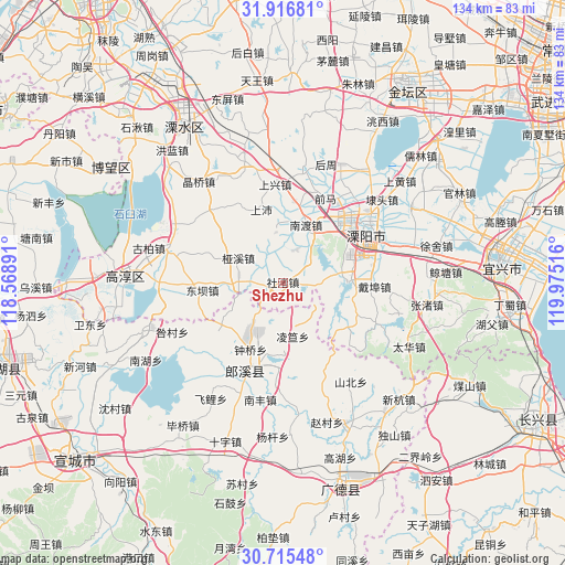
Shezhu GPS coordinates[2]
31° 19' 5.016" North, 119° 16' 19.308" East
| Map corner | latitude | longitude |
|---|---|---|
| Upper-left | 31.91681°, | 118.56891° |
| Center: | 31.31806°, | 119.27203° |
| Lower-right: | 30.71548°, | 119.97516° |
| Map W x H: | 133.6×133.6 km | = 83×83mi |
| max Lat: | 53.31946° ⇑42.8% North |
| Shezhu: | 31.31806° |
| min Lat: | ⇓57.2% South 18.22056° |
| min Long | Shezhu | max Long |
| 75.07348° | 119.27203° | 134.28917° |
| W 77.3%⇐ | ⇒22.7% E |
Elevation
Elevation of Shezhu is 10 m = 33 ft, and this is 474.8 m = 1558 ft below average elevation for this country.
| Max E: |
5622 m = 18445 ft | 89.9% |
| Avg. | 484.8 m = 1591 ft | |
| Shezhu | 10 m = 33 ft | |
Min E: |
-3 m = -10 ft | 10.1% |
See also: China elevation on elevation.city.
Geographical zone
Shezhu is located in North temperate zone (between Tropic of Cancer and the Arctic Circle). Distance of this Northern Tropic circle is 876.3 km =544.5 mi to South.| Distance of | km | miles | from Shezhu |
|---|---|---|---|
| North Pole | 6524.8 | 4054.3 | to North |
| Arctic Circle | 3918.9 | 2435.1 | to North |
| Tropic Cancer | 876.3 | 544.5 | to South |
| Equator | 3482.2 | 2163.7 | to South |


Nearby cities:
15 places around Shezhu: (largest is in red/bold)
• Dingbu
10.9 km =6.8 mi,  255°
255°
• Dongba
20.9 km =13 mi, 263°
• Gangnan
9.1 km =5.7 mi,  162°
162°
• Lingda
12.9 km =8 mi,  169°
169°
• Meizhu
8.6 km =5.3 mi,  223°
223°
• Nandu
14.8 km =9.2 mi,  21°
21°
• Nandu
15.5 km =9.6 mi,  38°
38°
• Shangpei
18.1 km =11.2 mi,  343°
343°
• Shangxing
21.2 km =13.2 mi,  3°
3°
• Shezhu
3.7 km =2.3 mi,  94°
94°
• Tianmuhu
15.9 km =9.9 mi, 86°
• Xinfa
20.5 km =12.7 mi,  231°
231°
• Yaxi
12.1 km =7.5 mi,  298°
298°
• Zhongqiao
17.6 km =10.9 mi,  205°
205°
• Zhoucheng
9.6 km =6 mi,  72°
72°
Sources, notices
• [Note1] Compared only with cities in China existing in our database
• [Src1] Map data: © OpenStreetMap contributors (CC-BY-SA)
• [Src2] Other city data from geonames.org with taken over terms of usage.
• [Src3] Geographical zone / Annual Mean Temperature by Robert A. Rohde @ Wikipedia
