Shayang geodata
Shayang (Hubei) is a seat of a third-order administrative division; located in China in Asia/Shanghai (GMT+8) time zone. In our database, there are 1268 cities with bigger population. Compared to other cities in China, 52.2% of cities are located further ↓South; 59.6% of cities are located further →East and 71.9% of cities have higher elevation than Shayang. Note1


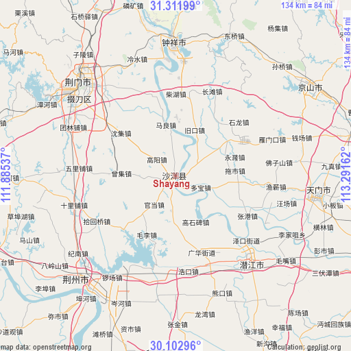
Shayang GPS coordinates[2]
30° 42' 33.732" North, 112° 35' 18.564" East
| Map corner | latitude | longitude |
|---|---|---|
| Upper-left | 31.31199°, | 111.88537° |
| Center: | 30.70937°, | 112.58849° |
| Lower-right: | 30.10296°, | 113.29162° |
| Map W x H: | 134.4×134.4 km | = 83.5×83.5mi |
| max Lat: | 53.31946° ⇑47.8% North |
| Shayang: | 30.70937° |
| min Lat: | ⇓52.2% South 18.22056° |
| min Long | Shayang | max Long |
| 75.07348° | 112.58849° | 134.28917° |
| W 40.4%⇐ | ⇒59.6% E |
Elevation
Elevation of Shayang is 45 m = 148 ft, and this is 439.8 m = 1443 ft below average elevation for this country.
| Max E: |
5622 m = 18445 ft | 71.9% |
| Avg. | 484.8 m = 1591 ft | |
| Shayang | 45 m = 148 ft | |
Min E: |
-3 m = -10 ft | 28.1% |
See also: China elevation on elevation.city.
Geographical zone
Shayang is located in North temperate zone (between Tropic of Cancer and the Arctic Circle). Distance of this Northern Tropic circle is 808.6 km =502.4 mi to South.| Distance of | km | miles | from Shayang |
|---|---|---|---|
| North Pole | 6592.5 | 4096.4 | to North |
| Arctic Circle | 3986.6 | 2477.2 | to North |
| Tropic Cancer | 808.6 | 502.4 | to South |
| Equator | 3414.6 | 2121.7 | to South |


Nearby cities:
15 places around Shayang: (largest is in red/bold)
• Chaihu
31.4 km =19.5 mi,  0°
0°
• Duobao
10.6 km =6.6 mi,  114°
114°
• Gaoshibei
19.2 km =11.9 mi,  156°
156°
• Gaoyang
9.6 km =6 mi,  310°
310°
• Guanghua
30.9 km =19.2 mi, 162°
• Hougang
29 km =18 mi,  222°
222°
• Jiukou
18.8 km =11.7 mi,  23°
23°
• Jiyukou
28.2 km =17.5 mi,  179°
179°
• Lishi
13.5 km =8.4 mi,  188°
188°
• Maliang
20 km =12.4 mi,  348°
348°
• Maoli
25.1 km =15.6 mi,  206°
206°
• Shenji
26.7 km =16.6 mi, 308°
• Tuoshi
22.9 km =14.2 mi,  84°
84°
• Wangchang
28.2 km =17.5 mi,  142°
142°
• Zengji
20.9 km =13 mi,  273°
273°
Sources, notices
• [Note1] Compared only with cities in China existing in our database
• [Src1] Map data: © OpenStreetMap contributors (CC-BY-SA)
• [Src2] Other city data from geonames.org with taken over terms of usage.
• [Src3] Geographical zone / Annual Mean Temperature by Robert A. Rohde @ Wikipedia
