Tuoshi geodata
Tuoshi (Hubei) is a seat of a fourth-order administrative division; located in China in Asia/Shanghai (GMT+8) time zone. In our database, there are 1268 cities with bigger population. Compared to other cities in China, 52.3% of cities are located further ↓South; 58.6% of cities are located further →East and 75.7% of cities have higher elevation than Tuoshi. Note1


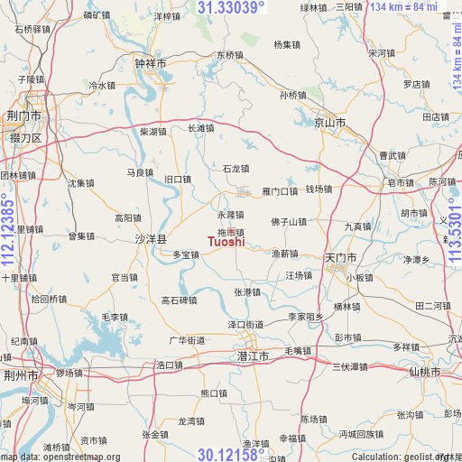
Tuoshi GPS coordinates[2]
30° 43' 40.368" North, 112° 49' 37.092" East
| Map corner | latitude | longitude |
|---|---|---|
| Upper-left | 31.33039°, | 112.12385° |
| Center: | 30.72788°, | 112.82697° |
| Lower-right: | 30.12158°, | 113.5301° |
| Map W x H: | 134.4×134.4 km | = 83.5×83.5mi |
| max Lat: | 53.31946° ⇑47.7% North |
| Tuoshi: | 30.72788° |
| min Lat: | ⇓52.3% South 18.22056° |
| min Long | Tuoshi | max Long |
| 75.07348° | 112.82697° | 134.28917° |
| W 41.4%⇐ | ⇒58.6% E |
Elevation
Elevation of Tuoshi is 35 m = 115 ft, and this is 449.8 m = 1476 ft below average elevation for this country.
| Max E: |
5622 m = 18445 ft | 75.7% |
| Avg. | 484.8 m = 1591 ft | |
| Tuoshi | 35 m = 115 ft | |
Min E: |
-3 m = -10 ft | 24.3% |
See also: China elevation on elevation.city.
Geographical zone
Tuoshi is located in North temperate zone (between Tropic of Cancer and the Arctic Circle). Distance of this Northern Tropic circle is 810.7 km =503.7 mi to South.| Distance of | km | miles | from Tuoshi |
|---|---|---|---|
| North Pole | 6590.4 | 4095.1 | to North |
| Arctic Circle | 3984.6 | 2475.9 | to North |
| Tropic Cancer | 810.7 | 503.7 | to South |
| Equator | 3416.6 | 2123 | to South |


Nearby cities:
15 places around Tuoshi: (largest is in red/bold)
• Duobao
14.6 km =9.1 mi,  243°
243°
• Fozishan
16.9 km =10.5 mi,  79°
79°
• Gaoshibei
24.7 km =15.3 mi,  217°
217°
• Huangtan
25.8 km =16 mi,  106°
106°
• Jiangchang
16.7 km =10.4 mi,  142°
142°
• Jiukou
21.6 km =13.4 mi,  314°
314°
• Shayang
22.9 km =14.2 mi,  264°
264°
• Shihe
24.5 km =15.2 mi, 82°
• Shilong
18.7 km =11.6 mi,  4°
4°
• Wangchang
23.3 km =14.5 mi,  122°
122°
• Wangchang
25.1 km =15.6 mi,  193°
193°
• Yanmenkou
18.4 km =11.4 mi,  49°
49°
• Yuxin
16.8 km =10.4 mi, 111°
• Zhanggang
18 km =11.2 mi,  164°
164°
• Zhugentan
26.6 km =16.5 mi, 164°
Sources, notices
• [Note1] Compared only with cities in China existing in our database
• [Src1] Map data: © OpenStreetMap contributors (CC-BY-SA)
• [Src2] Other city data from geonames.org with taken over terms of usage.
• [Src3] Geographical zone / Annual Mean Temperature by Robert A. Rohde @ Wikipedia
