Shancheng geodata
Shancheng (Fujian) is a seat of a third-order administrative division; located in China in Asia/Shanghai (GMT+8) time zone. In our database, there are 1268 cities with bigger population. Compared to other cities in China, 79% of cities are located further ↑North; 66.9% of cities are located further ←West and 63.4% of cities have lower elevation than Shancheng. Note1


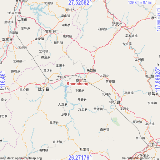
Shancheng GPS coordinates[2]
26° 54' 1.908" North, 117° 9' 47.232" East
| Map corner | latitude | longitude |
|---|---|---|
| Upper-left | 27.52582°, | 116.46° |
| Center: | 26.90053°, | 117.16312° |
| Lower-right: | 26.27176°, | 117.86625° |
| Map W x H: | 139.4×139.4 km | = 86.6×86.6mi |
| max Lat: | 53.31946° ⇑79% North |
| Shancheng: | 26.90053° |
| min Lat: | ⇓21% South 18.22056° |
| min Long | Shancheng | max Long |
| 75.07348° | 117.16312° | 134.28917° |
| W 66.9%⇐ | ⇒33.1% E |
Elevation
Elevation of Shancheng is 303 m = 994 ft, and this is 181.8 m = 596 ft below average elevation for this country.
| Max E: |
5622 m = 18445 ft | 36.6% |
| Avg. | 484.8 m = 1591 ft | |
| Shancheng | 303 m = 994 ft | |
Min E: |
-3 m = -10 ft | 63.4% |
See also: China elevation on elevation.city.
Geographical zone
Shancheng is located in North temperate zone (between Tropic of Cancer and the Arctic Circle). Distance of this Northern Tropic circle is 385.1 km =239.3 mi to South.| Distance of | km | miles | from Shancheng |
|---|---|---|---|
| North Pole | 7016 | 4359.5 | to North |
| Arctic Circle | 4410.1 | 2740.3 | to North |
| Tropic Cancer | 385.1 | 239.3 | to South |
| Equator | 2991.1 | 1858.6 | to South |


Nearby cities:
15 places around Shancheng: (largest is in red/bold)
• Anren
27.7 km =17.2 mi,  73°
73°
• Dabu
25.7 km =16 mi,  216°
216°
• Datian
16.5 km =10.3 mi,  280°
280°
• Dayuan
21.3 km =13.2 mi,  78°
78°
• Guangming
25.4 km =15.8 mi,  117°
117°
• Hedong
32.1 km =19.9 mi,  256°
256°
• Huangfang
29.5 km =18.3 mi,  287°
287°
• Huangtan
29.3 km =18.2 mi,  147°
147°
• Kaishan
16.5 km =10.3 mi,  174°
174°
• Long’an
32.3 km =20.1 mi,  203°
203°
• Wanquan
25.6 km =15.9 mi,  175°
175°
• Wan’an
26 km =16.2 mi,  90°
90°
• Xiaqu
8.6 km =5.3 mi, 184°
• Yufang
9.1 km =5.7 mi, 88°
• Zhukou
13 km =8.1 mi,  47°
47°
Sources, notices
• [Note1] Compared only with cities in China existing in our database
• [Src1] Map data: © OpenStreetMap contributors (CC-BY-SA)
• [Src2] Other city data from geonames.org with taken over terms of usage.
• [Src3] Geographical zone / Annual Mean Temperature by Robert A. Rohde @ Wikipedia
