Kaishan geodata
Kaishan (Fujian) is a seat of a fourth-order administrative division; located in China in Asia/Shanghai (GMT+8) time zone. In our database, there are 1268 cities with bigger population. Compared to other cities in China, 79.5% of cities are located further ↑North; 67% of cities are located further ←West and 69.1% of cities have lower elevation than Kaishan. Note1


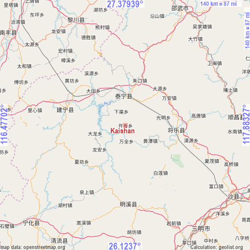
Kaishan GPS coordinates[2]
26° 45' 11.808" North, 117° 10' 48.504" East
| Map corner | latitude | longitude |
|---|---|---|
| Upper-left | 27.37939°, | 116.47702° |
| Center: | 26.75328°, | 117.18014° |
| Lower-right: | 26.1237°, | 117.88327° |
| Map W x H: | 139.6×139.6 km | = 86.7×86.7mi |
| max Lat: | 53.31946° ⇑79.5% North |
| Kaishan: | 26.75328° |
| min Lat: | ⇓20.5% South 18.22056° |
| min Long | Kaishan | max Long |
| 75.07348° | 117.18014° | 134.28917° |
| W 67%⇐ | ⇒33% E |
Elevation
Elevation of Kaishan is 395 m = 1296 ft, and this is 89.8 m = 295 ft below average elevation for this country.
| Max E: |
5622 m = 18445 ft | 30.9% |
| Avg. | 484.8 m = 1591 ft | |
| Kaishan | 395 m = 1296 ft | |
Min E: |
-3 m = -10 ft | 69.1% |
See also: China elevation on elevation.city.
Geographical zone
Kaishan is located in North temperate zone (between Tropic of Cancer and the Arctic Circle). Distance of this Northern Tropic circle is 368.8 km =229.2 mi to South.| Distance of | km | miles | from Kaishan |
|---|---|---|---|
| North Pole | 7032.4 | 4369.7 | to North |
| Arctic Circle | 4426.5 | 2750.5 | to North |
| Tropic Cancer | 368.8 | 229.2 | to South |
| Equator | 2974.7 | 1848.4 | to South |


Nearby cities:
15 places around Kaishan: (largest is in red/bold)
• Dabu
17.5 km =10.9 mi,  255°
255°
• Datian
26.5 km =16.5 mi,  317°
317°
• Dayuan
28.3 km =17.6 mi,  42°
42°
• Guangming
21.3 km =13.2 mi,  77°
77°
• Guyong
28.7 km =17.8 mi,  94°
94°
• Huangtan
16.3 km =10.1 mi,  121°
121°
• Long’an
19.6 km =12.2 mi,  227°
227°
• Nankou
27.6 km =17.1 mi, 120°
• Shancheng
16.5 km =10.3 mi,  354°
354°
• Wanquan
9.1 km =5.7 mi,  176°
176°
• Wan’an
29.1 km =18.1 mi,  56°
56°
• Xiafang
31.7 km =19.7 mi, 230°
• Xiaqu
8.2 km =5.1 mi,  343°
343°
• Yufang
18.1 km =11.2 mi,  24°
24°
• Zhukou
26.3 km =16.3 mi, 17°
Sources, notices
• [Note1] Compared only with cities in China existing in our database
• [Src1] Map data: © OpenStreetMap contributors (CC-BY-SA)
• [Src2] Other city data from geonames.org with taken over terms of usage.
• [Src3] Geographical zone / Annual Mean Temperature by Robert A. Rohde @ Wikipedia
