Seke geodata
Seke (Sichuan) is a seat of a third-order administrative division; located in China in Asia/Shanghai (GMT+8) time zone. In our database, there are 1268 cities with bigger population. Compared to other cities in China, 62.8% of cities are located further ↓South; 94.3% of cities are located further →East and 98.4% of cities have lower elevation than Seke. Note1


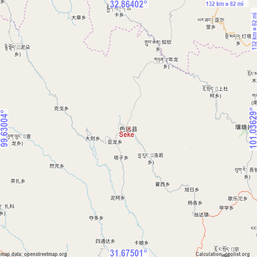
Seke GPS coordinates[2]
32° 16' 17.256" North, 100° 19' 59.376" East
| Map corner | latitude | longitude |
|---|---|---|
| Upper-left | 32.86402°, | 99.63004° |
| Center: | 32.27146°, | 100.33316° |
| Lower-right: | 31.67501°, | 101.03629° |
| Map W x H: | 132.2×132.2 km | = 82.1×82.1mi |
| max Lat: | 53.31946° ⇑37.2% North |
| Seke: | 32.27146° |
| min Lat: | ⇓62.8% South 18.22056° |
| min Long | Seke | max Long |
| 75.07348° | 100.33316° | 134.28917° |
| W 5.7%⇐ | ⇒94.3% E |
Elevation
Elevation of Seke is 3884 m = 12743 ft, and this is 3399.2 m = 11152 ft above average elevation for this country.
| Max E: |
5622 m = 18445 ft | 1.6% |
| Seke | 3884 m 12743 ft | |
| Avg. | 484.8 m = 1591 ft | |
Min E: |
-3 m = -10 ft | 98.4% |
See also: China elevation on elevation.city.
Geographical zone
Seke is located in North temperate zone (between Tropic of Cancer and the Arctic Circle). Distance of this Northern Tropic circle is 982.3 km =610.4 mi to South.| Distance of | km | miles | from Seke |
|---|---|---|---|
| North Pole | 6418.8 | 3988.5 | to North |
| Arctic Circle | 3812.9 | 2369.2 | to North |
| Tropic Cancer | 982.3 | 610.4 | to South |
| Equator | 3588.2 | 2229.6 | to South |


Nearby cities:
15 places around Seke: (largest is in red/bold)
• Dagkar
84.2 km =52.3 mi,  342°
342°
• Dimda
72.9 km =45.3 mi,  50°
50°
• Duogongma
94.9 km =59 mi,  14°
14°
• Ganzi
78.4 km =48.7 mi,  204°
204°
• Gyimkar
61 km =37.9 mi,  355°
355°
• Jiangritang
82.9 km =51.5 mi,  29°
29°
• Kehe
105.2 km =65.4 mi,  70°
70°
• Markog
91.3 km =56.7 mi, 8°
• Marzhing
114.5 km =71.1 mi,  3°
3°
• Sailaitang
83 km =51.6 mi, 27°
• Shang Boingor
99.1 km =61.6 mi,  314°
314°
• Xia Boingor
83.5 km =51.9 mi, 314°
• Xindou
102.6 km =63.8 mi,  161°
161°
• Yartang
69 km =42.9 mi,  37°
37°
• Zhiqin
45.9 km =28.5 mi,  19°
19°
Sources, notices
• [Note1] Compared only with cities in China existing in our database
• [Src1] Map data: © OpenStreetMap contributors (CC-BY-SA)
• [Src2] Other city data from geonames.org with taken over terms of usage.
• [Src3] Geographical zone / Annual Mean Temperature by Robert A. Rohde @ Wikipedia
