Sanbiao geodata
Sanbiao (Jiangxi) is a seat of a fourth-order administrative division; located in China in Asia/Shanghai (GMT+8) time zone. In our database, there are 1268 cities with bigger population. Compared to other cities in China, 86.2% of cities are located further ↑North; 57.5% of cities are located further ←West and 71% of cities have lower elevation than Sanbiao. Note1


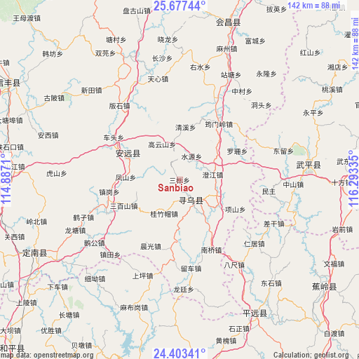
Sanbiao GPS coordinates[2]
25° 2' 31.488" North, 115° 35' 24.792" East
| Map corner | latitude | longitude |
|---|---|---|
| Upper-left | 25.67744°, | 114.8871° |
| Center: | 25.04208°, | 115.59022° |
| Lower-right: | 24.40341°, | 116.29335° |
| Map W x H: | 141.7×141.7 km | = 88×88mi |
| max Lat: | 53.31946° ⇑86.2% North |
| Sanbiao: | 25.04208° |
| min Lat: | ⇓13.8% South 18.22056° |
| min Long | Sanbiao | max Long |
| 75.07348° | 115.59022° | 134.28917° |
| W 57.5%⇐ | ⇒42.5% E |
Elevation
Elevation of Sanbiao is 430 m = 1411 ft, and this is 54.8 m = 180 ft below average elevation for this country.
| Max E: |
5622 m = 18445 ft | 29% |
| Avg. | 484.8 m = 1591 ft | |
| Sanbiao | 430 m = 1411 ft | |
Min E: |
-3 m = -10 ft | 71% |
See also: China elevation on elevation.city.
Geographical zone
Sanbiao is located in North temperate zone (between Tropic of Cancer and the Arctic Circle). Distance of this Northern Tropic circle is 178.5 km =110.9 mi to South.| Distance of | km | miles | from Sanbiao |
|---|---|---|---|
| North Pole | 7222.6 | 4487.9 | to North |
| Arctic Circle | 4616.8 | 2868.7 | to North |
| Tropic Cancer | 178.5 | 110.9 | to South |
| Equator | 2784.4 | 1730.1 | to South |


Nearby cities:
15 places around Sanbiao: (largest is in red/bold)
• Changning
10.9 km =6.8 mi,  151°
151°
• Chengjiang
13.3 km =8.3 mi,  80°
80°
• Fengshan
21.2 km =13.2 mi,  273°
273°
• Gaoyunshan
15.7 km =9.8 mi,  334°
334°
• Guizhumao
14.6 km =9.1 mi,  204°
204°
• Jitan
18.6 km =11.6 mi,  123°
123°
• Lianjiang
22.2 km =13.8 mi,  296°
296°
• Luoshan
25.5 km =15.8 mi,  63°
63°
• Qingxi
21 km =13 mi,  6°
6°
• Sanbaishan
24.2 km =15 mi,  245°
245°
• Shuiyuan
10.5 km =6.5 mi,  27°
27°
• Wenfeng
9.6 km =6 mi, 153°
• Xiangshan
24.9 km =15.5 mi, 117°
• Xinshan
23 km =14.3 mi, 297°
• Yunmenling
27 km =16.8 mi,  35°
35°
Sources, notices
• [Note1] Compared only with cities in China existing in our database
• [Src1] Map data: © OpenStreetMap contributors (CC-BY-SA)
• [Src2] Other city data from geonames.org with taken over terms of usage.
• [Src3] Geographical zone / Annual Mean Temperature by Robert A. Rohde @ Wikipedia
