Chengjiang geodata
Chengjiang (Jiangxi) is a seat of a fourth-order administrative division; located in China in Asia/Shanghai (GMT+8) time zone. In our database, there are 1268 cities with bigger population. Compared to other cities in China, 86.1% of cities are located further ↑North; 58.3% of cities are located further ←West and 63.4% of cities have lower elevation than Chengjiang. Note1


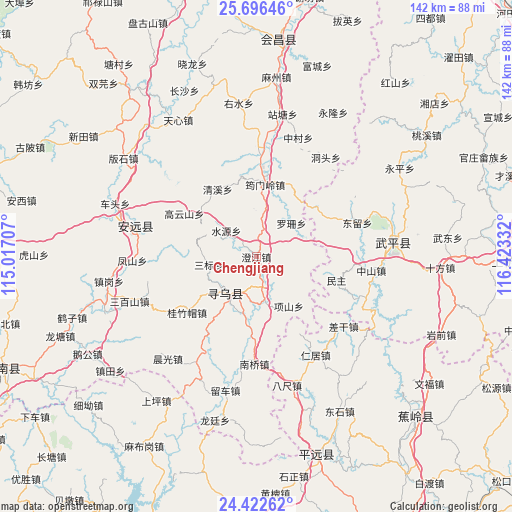
Chengjiang GPS coordinates[2]
25° 3' 40.32" North, 115° 43' 12.684" East
| Map corner | latitude | longitude |
|---|---|---|
| Upper-left | 25.69646°, | 115.01707° |
| Center: | 25.0612°, | 115.72019° |
| Lower-right: | 24.42262°, | 116.42332° |
| Map W x H: | 141.6×141.6 km | = 88×88mi |
| max Lat: | 53.31946° ⇑86.1% North |
| Chengjiang: | 25.0612° |
| min Lat: | ⇓13.9% South 18.22056° |
| min Long | Chengjiang | max Long |
| 75.07348° | 115.72019° | 134.28917° |
| W 58.3%⇐ | ⇒41.7% E |
Elevation
Elevation of Chengjiang is 303 m = 994 ft, and this is 181.8 m = 596 ft below average elevation for this country.
| Max E: |
5622 m = 18445 ft | 36.6% |
| Avg. | 484.8 m = 1591 ft | |
| Chengjiang | 303 m = 994 ft | |
Min E: |
-3 m = -10 ft | 63.4% |
See also: China elevation on elevation.city.
Geographical zone
Chengjiang is located in North temperate zone (between Tropic of Cancer and the Arctic Circle). Distance of this Northern Tropic circle is 180.6 km =112.2 mi to South.| Distance of | km | miles | from Chengjiang |
|---|---|---|---|
| North Pole | 7220.5 | 4486.6 | to North |
| Arctic Circle | 4614.6 | 2867.4 | to North |
| Tropic Cancer | 180.6 | 112.2 | to South |
| Equator | 2786.5 | 1731.5 | to South |


Nearby cities:
15 places around Chengjiang: (largest is in red/bold)
• Changling
22.1 km =13.7 mi,  21°
21°
• Changning
14.1 km =8.8 mi,  213°
213°
• Dongliu
28.6 km =17.8 mi,  71°
71°
• Gaoyunshan
23.3 km =14.5 mi,  300°
300°
• Guizhumao
24.6 km =15.3 mi,  231°
231°
• Jitan
12.7 km =7.9 mi,  169°
169°
• Luoshan
13.4 km =8.3 mi,  46°
46°
• Minzhu
23.1 km =14.4 mi,  106°
106°
• Nanqiao
29.7 km =18.5 mi,  181°
181°
• Qingxi
21.6 km =13.4 mi,  330°
330°
• Sanbiao
13.3 km =8.3 mi,  260°
260°
• Shuiyuan
11 km =6.8 mi,  310°
310°
• Wenfeng
13.8 km =8.6 mi,  219°
219°
• Xiangshan
16.3 km =10.1 mi,  146°
146°
• Yunmenling
20.1 km =12.5 mi,  6°
6°
Sources, notices
• [Note1] Compared only with cities in China existing in our database
• [Src1] Map data: © OpenStreetMap contributors (CC-BY-SA)
• [Src2] Other city data from geonames.org with taken over terms of usage.
• [Src3] Geographical zone / Annual Mean Temperature by Robert A. Rohde @ Wikipedia
