Le’anpu Miaozudongzuxiang geodata
Le’anpu Miaozudongzuxiang (Hunan) is a populated place; located in China in Asia/Shanghai (GMT+8) time zone. With population of 620 people, there are 1247 cities with bigger population in this country. Compared to other cities in China, 80.5% of cities are located further ↑North; 71.8% of cities are located further →East and 72.1% of cities have lower elevation than Le’anpu Miaozudongzuxiang. Note1
Current local time in Le’anpu Miaozudongzuxiang:
03:26 PM, TuesdayDifference from your time zone: hours


Le’anpu Miaozudongzuxiang GPS coordinates[2]
26° 29' 39.984" North, 109° 54' 10.008" East
| Map corner | latitude | longitude |
|---|---|---|
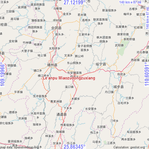
| Upper-left | 27.12199°, | 109.19966° |
| Center: | 26.49444°, | 109.90278° |
| Lower-right: | 25.86345°, | 110.60591° |
| Map W x H: | 139.9×139.9 km | = 86.9×86.9mi |
| max Lat: | 53.31946° ⇑80.5% North |
| Le’anpu Miaozudongzuxiang: | 26.49444° |
| min Lat: | ⇓19.5% South 18.22056° |
| min Long | Le’anpu Miaoz | max Long |
| 75.07348° | 109.90278° | 134.28917° |
| W 28.2%⇐ | ⇒71.8% E |
Elevation
Elevation of Le’anpu Miaozudongzuxiang is 455 m = 1493 ft, and this is 29.8 m = 98 ft below average elevation for this country.
| Max E: |
5622 m = 18445 ft | 27.9% |
| Avg. | 484.8 m = 1591 ft | |
| Le’anpu Miaozudongzuxiang | 455 m = 1493 ft | |
Min E: |
-3 m = -10 ft | 72.1% |
See also: China elevation on elevation.city.
Geographical zone
Le’anpu Miaozudongzuxiang is located in North temperate zone (between Tropic of Cancer and the Arctic Circle). Distance of this Northern Tropic circle is 340 km =211.3 mi to South.| Distance of | km | miles | from Le’anpu Miaozudongzuxiang |
|---|---|---|---|
| North Pole | 7061.2 | 4387.6 | to North |
| Arctic Circle | 4455.3 | 2768.4 | to North |
| Tropic Cancer | 340 | 211.3 | to South |
| Equator | 2945.9 | 1830.5 | to South |


Nearby cities:
15 places around Le’anpu Miaozudongzuxiang: (largest is in red/bold)
• Changpu
22.3 km =13.9 mi,  66°
66°
• Chang’anying
31.6 km =19.6 mi,  144°
144°
• Dankou
37 km =23 mi,  113°
113°
• Diyangping
38.7 km =24 mi,  230°
230°
• Dongshan Dongzuxiang
11.2 km =7 mi,  356°
356°
• Guanxia Miaozuxiang
38.2 km =23.7 mi,  76°
76°
• Hekou
31.9 km =19.8 mi,  30°
30°
• Lianshan
39.8 km =24.7 mi,  329°
329°
• Linkou
27.7 km =17.2 mi,  188°
188°
• Pukou
34.7 km =21.6 mi,  275°
275°
• Quyang
27.8 km =17.3 mi,  288°
288°
• Rulin
39.7 km =24.7 mi, 114°
• Xianxi
31.4 km =19.5 mi,  235°
235°
• Zhaishi Miaozu Dongzuxiang
14.1 km =8.8 mi,  87°
87°
• Zhuzhoujiang Miaozuxiang
26.2 km =16.3 mi,  39°
39°
Sources, notices
• [Note1] Compared only with cities in China existing in our database
• [Src1] Map data: © OpenStreetMap contributors (CC-BY-SA)
• [Src2] Other city data from geonames.org with taken over terms of usage.
• [Src3] Geographical zone / Annual Mean Temperature by Robert A. Rohde @ Wikipedia
