Qingshizui geodata
Qingshizui (Qinghai) is a seat of a fourth-order administrative division; located in China in Asia/Shanghai (GMT+8) time zone. In our database, there are 1268 cities with bigger population. Compared to other cities in China, 80.2% of cities are located further ↓South; 93.5% of cities are located further →East and 96.7% of cities have lower elevation than Qingshizui. Note1


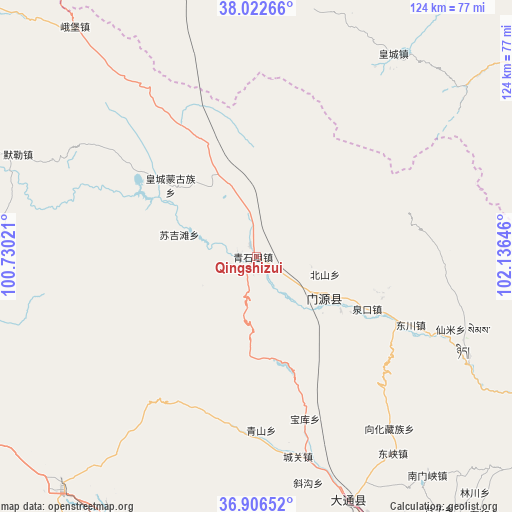
Qingshizui GPS coordinates[2]
37° 28' 0.012" North, 101° 25' 59.988" East
| Map corner | latitude | longitude |
|---|---|---|
| Upper-left | 38.02266°, | 100.73021° |
| Center: | 37.46667°, | 101.43333° |
| Lower-right: | 36.90652°, | 102.13646° |
| Map W x H: | 124.1×124.1 km | = 77.1×77.1mi |
| max Lat: | 53.31946° ⇑19.8% North |
| Qingshizui: | 37.46667° |
| min Lat: | ⇓80.2% South 18.22056° |
| min Long | Qingshizui | max Long |
| 75.07348° | 101.43333° | 134.28917° |
| W 6.5%⇐ | ⇒93.5% E |
Elevation
Elevation of Qingshizui is 2940 m = 9646 ft, and this is 2455.2 m = 8055 ft above average elevation for this country.
| Max E: |
5622 m = 18445 ft | 3.3% |
| Qingshizui | 2940 m 9646 ft | |
| Avg. | 484.8 m = 1591 ft | |
Min E: |
-3 m = -10 ft | 96.7% |
See also: China elevation on elevation.city.
Geographical zone
Qingshizui is located in North temperate zone (between Tropic of Cancer and the Arctic Circle). Distance of this Northern Tropic circle is 1560 km =969.3 mi to South.| Distance of | km | miles | from Qingshizui |
|---|---|---|---|
| North Pole | 5841.2 | 3629.6 | to North |
| Arctic Circle | 3235.3 | 2010.3 | to North |
| Tropic Cancer | 1560 | 969.3 | to South |
| Equator | 4165.9 | 2588.6 | to South |


Nearby cities:
15 places around Qingshizui: (largest is in red/bold)
• Beitan
59.6 km =37 mi,  34°
34°
• Dongchuan
37.2 km =23.1 mi,  107°
107°
• Dongtan
54.8 km =34.1 mi,  36°
36°
• Dongxia
57.1 km =35.5 mi,  146°
146°
• Duolin
44 km =27.3 mi,  177°
177°
• Huangcheng
25.9 km =16.1 mi,  307°
307°
• Huangjiazhai
71 km =44.1 mi,  159°
159°
• Maying
62.1 km =38.6 mi,  23°
23°
• Muri
67.1 km =41.7 mi,  291°
291°
• Nanmenxia
67.5 km =41.9 mi,  141°
141°
• Obo
70.7 km =43.9 mi,  321°
321°
• Qiaotou
62.8 km =39 mi, 160°
• Shangwuzhuang
68.1 km =42.3 mi, 180°
• Sujitan
21.5 km =13.4 mi, 286°
• Xinzhuang
46.4 km =28.8 mi,  165°
165°
Sources, notices
• [Note1] Compared only with cities in China existing in our database
• [Src1] Map data: © OpenStreetMap contributors (CC-BY-SA)
• [Src2] Other city data from geonames.org with taken over terms of usage.
• [Src3] Geographical zone / Annual Mean Temperature by Robert A. Rohde @ Wikipedia
