Dongtan geodata
Dongtan (Gansu) is a seat of a fourth-order administrative division; located in China in Asia/Shanghai (GMT+8) time zone. In our database, there are 1268 cities with bigger population. Compared to other cities in China, 80.7% of cities are located further ↓South; 93.1% of cities are located further →East and 96.2% of cities have lower elevation than Dongtan. Note1


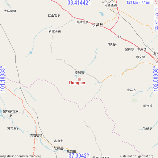
Dongtan GPS coordinates[2]
37° 51' 41.04" North, 101° 48' 23.22" East
| Map corner | latitude | longitude |
|---|---|---|
| Upper-left | 38.41442°, | 101.10333° |
| Center: | 37.8614°, | 101.80645° |
| Lower-right: | 37.3042°, | 102.50958° |
| Map W x H: | 123.4×123.4 km | = 76.7×76.7mi |
| max Lat: | 53.31946° ⇑19.3% North |
| Dongtan: | 37.8614° |
| min Lat: | ⇓80.7% South 18.22056° |
| min Long | Dongtan | max Long |
| 75.07348° | 101.80645° | 134.28917° |
| W 6.9%⇐ | ⇒93.1% E |
Elevation
Elevation of Dongtan is 2668 m = 8753 ft, and this is 2183.2 m = 7163 ft above average elevation for this country.
| Max E: |
5622 m = 18445 ft | 3.8% |
| Dongtan | 2668 m 8753 ft | |
| Avg. | 484.8 m = 1591 ft | |
Min E: |
-3 m = -10 ft | 96.2% |
See also: China elevation on elevation.city.
Geographical zone
Dongtan is located in North temperate zone (between Tropic of Cancer and the Arctic Circle). Distance of this Northern Tropic circle is 1603.9 km =996.6 mi to South.| Distance of | km | miles | from Dongtan |
|---|---|---|---|
| North Pole | 5797.3 | 3602.3 | to North |
| Arctic Circle | 3191.4 | 1983 | to North |
| Tropic Cancer | 1603.9 | 996.6 | to South |
| Equator | 4209.8 | 2615.8 | to South |


Nearby cities:
15 places around Dongtan: (largest is in red/bold)
• Beitan
5.1 km =3.2 mi,  15°
15°
• Damaying
77.3 km =48 mi,  316°
316°
• Dongchuan
54.9 km =34.1 mi,  177°
177°
• Dongdajie
73 km =45.4 mi,  84°
84°
• Hongshanyao
52 km =32.3 mi,  339°
339°
• Hongtu
77.5 km =48.2 mi,  278°
278°
• Huangcheng
60.2 km =37.4 mi,  242°
242°
• Maying
15.4 km =9.6 mi,  328°
328°
• Obo
77.5 km =48.2 mi, 278°
• Qingshizui
54.8 km =34.1 mi,  216°
216°
• Sujitan
65.4 km =40.6 mi,  234°
234°
• Wuwei
72.8 km =45.2 mi, 84°
• Xinchengzi
40.1 km =24.9 mi, 333°
• Yangxiang
21.7 km =13.5 mi,  48°
48°
• Yongchang Chengguanzhen
49.2 km =30.6 mi, 22°
Sources, notices
• [Note1] Compared only with cities in China existing in our database
• [Src1] Map data: © OpenStreetMap contributors (CC-BY-SA)
• [Src2] Other city data from geonames.org with taken over terms of usage.
• [Src3] Geographical zone / Annual Mean Temperature by Robert A. Rohde @ Wikipedia
