Beitan geodata
Beitan (Gansu) is a seat of a fourth-order administrative division; located in China in Asia/Shanghai (GMT+8) time zone. In our database, there are 1268 cities with bigger population. Compared to other cities in China, 80.8% of cities are located further ↓South; 93.1% of cities are located further →East and 96% of cities have lower elevation than Beitan. Note1


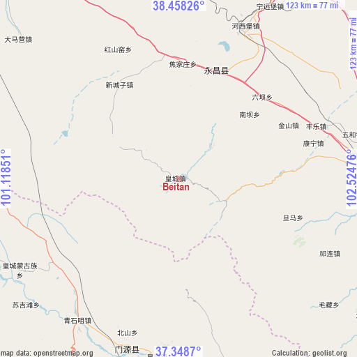
Beitan GPS coordinates[2]
37° 54' 20.052" North, 101° 49' 17.868" East
| Map corner | latitude | longitude |
|---|---|---|
| Upper-left | 38.45826°, | 101.11851° |
| Center: | 37.90557°, | 101.82163° |
| Lower-right: | 37.3487°, | 102.52476° |
| Map W x H: | 123.4×123.4 km | = 76.7×76.7mi |
| max Lat: | 53.31946° ⇑19.2% North |
| Beitan: | 37.90557° |
| min Lat: | ⇓80.8% South 18.22056° |
| min Long | Beitan | max Long |
| 75.07348° | 101.82163° | 134.28917° |
| W 6.9%⇐ | ⇒93.1% E |
Elevation
Elevation of Beitan is 2551 m = 8369 ft, and this is 2066.2 m = 6779 ft above average elevation for this country.
| Max E: |
5622 m = 18445 ft | 4% |
| Beitan | 2551 m 8369 ft | |
| Avg. | 484.8 m = 1591 ft | |
Min E: |
-3 m = -10 ft | 96% |
See also: China elevation on elevation.city.
Geographical zone
Beitan is located in North temperate zone (between Tropic of Cancer and the Arctic Circle). Distance of this Northern Tropic circle is 1608.8 km =999.7 mi to South.| Distance of | km | miles | from Beitan |
|---|---|---|---|
| North Pole | 5792.4 | 3599.2 | to North |
| Arctic Circle | 3186.5 | 1980 | to North |
| Tropic Cancer | 1608.8 | 999.7 | to South |
| Equator | 4214.7 | 2618.9 | to South |


Nearby cities:
15 places around Beitan: (largest is in red/bold)
• Damaying
74.7 km =46.4 mi,  313°
313°
• Dongchuan
59.8 km =37.2 mi,  178°
178°
• Dongdajie
71.3 km =44.3 mi,  88°
88°
• Dongtan
5.1 km =3.2 mi,  195°
195°
• Guangzhoulu
72.6 km =45.1 mi,  24°
24°
• Hongshanyao
48 km =29.8 mi,  336°
336°
• Huangcheng
63.8 km =39.6 mi,  238°
238°
• Jinchang
73.7 km =45.8 mi,  26°
26°
• Maying
12.5 km =7.8 mi, 310°
• Qingshizui
59.6 km =37 mi,  214°
214°
• Sujitan
69.4 km =43.1 mi,  232°
232°
• Wuwei
71.1 km =44.2 mi, 88°
• Xinchengzi
36.5 km =22.7 mi,  327°
327°
• Yangxiang
17.7 km =11 mi,  58°
58°
• Yongchang Chengguanzhen
44.1 km =27.4 mi, 23°
Sources, notices
• [Note1] Compared only with cities in China existing in our database
• [Src1] Map data: © OpenStreetMap contributors (CC-BY-SA)
• [Src2] Other city data from geonames.org with taken over terms of usage.
• [Src3] Geographical zone / Annual Mean Temperature by Robert A. Rohde @ Wikipedia
