Qingdao geodata
Qingdao (Shandong) is a seat of a second-order administrative division; located in China in Asia/Shanghai (GMT+8) time zone. With population of 3,718,835 people, there are 23 cities with bigger population in this country. Compared to other cities in China, 77.3% of cities are located further ↓South; 84.4% of cities are located further ←West and 84.9% of cities have higher elevation than Qingdao. Note1


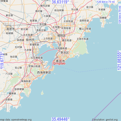
Qingdao GPS coordinates[2]
36° 3' 53.568" North, 120° 22' 49.512" East
| Map corner | latitude | longitude |
|---|---|---|
| Upper-left | 36.63119°, | 119.6773° |
| Center: | 36.06488°, | 120.38042° |
| Lower-right: | 35.49446°, | 121.08355° |
| Map W x H: | 126.4×126.4 km | = 78.5×78.5mi |
| max Lat: | 53.31946° ⇑22.7% North |
| Qingdao: | 36.06488° |
| min Lat: | ⇓77.3% South 18.22056° |
| min Long | Qingdao | max Long |
| 75.07348° | 120.38042° | 134.28917° |
| W 84.4%⇐ | ⇒15.6% E |
Elevation
Elevation of Qingdao is 16 m = 52 ft, and this is 468.8 m = 1538 ft below average elevation for this country.
| Max E: |
5622 m = 18445 ft | 84.9% |
| Avg. | 484.8 m = 1591 ft | |
| Qingdao | 16 m = 52 ft | |
Min E: |
-3 m = -10 ft | 15.1% |
See also: Qingdao elevation on elevation.city.
Geographical zone
Qingdao is located in North temperate zone (between Tropic of Cancer and the Arctic Circle). Distance of this Northern Tropic circle is 1404.1 km =872.5 mi to South.| Distance of | km | miles | from Qingdao |
|---|---|---|---|
| North Pole | 5997 | 3726.4 | to North |
| Arctic Circle | 3391.1 | 2107.1 | to North |
| Tropic Cancer | 1404.1 | 872.5 | to South |
| Equator | 4010 | 2491.7 | to South |


Nearby cities:
15 places around Qingdao: (largest is in red/bold)
• Beizhai
21.8 km =13.5 mi,  37°
37°
• Changjianglu Jiedao
21.6 km =13.4 mi,  239°
239°
• Chengyang
27.4 km =17 mi,  359°
359°
• Dengying
19.3 km =12 mi,  64°
64°
• Gaomi
66.5 km =41.3 mi,  302°
302°
• Jiaozhou
41.7 km =25.9 mi,  305°
305°
• Jimo
36.9 km =22.9 mi,  11°
11°
• Kutao
13.1 km =8.1 mi,  47°
47°
• Mizhou
88.7 km =55.1 mi,  264°
264°
• Pingdu
88.9 km =55.2 mi,  334°
334°
• Qingshancun
28.9 km =18 mi,  69°
69°
• Shazikou
15.2 km =9.4 mi, 68°
• Shilaorencun
10.4 km =6.5 mi, 69°
• Yinzhu
41.9 km =26 mi, 240°
• Zhu Cheng City
88.3 km =54.9 mi, 264°
Sources, notices
• [Note1] Compared only with cities in China existing in our database
• [Src1] Map data: © OpenStreetMap contributors (CC-BY-SA)
• [Src2] Other city data from geonames.org with taken over terms of usage.
• [Src3] Geographical zone / Annual Mean Temperature by Robert A. Rohde @ Wikipedia
