Qingshancun geodata
Qingshancun (Shandong) is a populated place; located in China in Asia/Shanghai (GMT+8) time zone. With population of 2,233 people, there are 1008 cities with bigger population in this country. Compared to other cities in China, 77.6% of cities are located further ↓South; 86.1% of cities are located further ←West and 68.7% of cities have higher elevation than Qingshancun. Note1


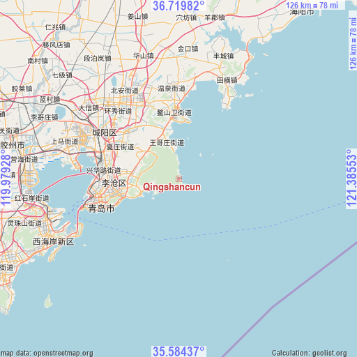
Qingshancun GPS coordinates[2]
36° 9' 14.94" North, 120° 40' 56.64" East
| Map corner | latitude | longitude |
|---|---|---|
| Upper-left | 36.71982°, | 119.97928° |
| Center: | 36.15415°, | 120.6824° |
| Lower-right: | 35.58437°, | 121.38553° |
| Map W x H: | 126.3×126.2 km | = 78.5×78.4mi |
| max Lat: | 53.31946° ⇑22.4% North |
| Qingshancun: | 36.15415° |
| min Lat: | ⇓77.6% South 18.22056° |
| min Long | Qingshancun | max Long |
| 75.07348° | 120.6824° | 134.28917° |
| W 86.1%⇐ | ⇒13.9% E |
Elevation
Elevation of Qingshancun is 57 m = 187 ft, and this is 427.8 m = 1404 ft below average elevation for this country.
| Max E: |
5622 m = 18445 ft | 68.7% |
| Avg. | 484.8 m = 1591 ft | |
| Qingshancun | 57 m = 187 ft | |
Min E: |
-3 m = -10 ft | 31.3% |
See also: China elevation on elevation.city.
Geographical zone
Qingshancun is located in North temperate zone (between Tropic of Cancer and the Arctic Circle). Distance of this Northern Tropic circle is 1414 km =878.6 mi to South.| Distance of | km | miles | from Qingshancun |
|---|---|---|---|
| North Pole | 5987.1 | 3720.2 | to North |
| Arctic Circle | 3381.2 | 2101 | to North |
| Tropic Cancer | 1414 | 878.6 | to South |
| Equator | 4020 | 2497.9 | to South |


Nearby cities:
15 places around Qingshancun: (largest is in red/bold)
• Beizhai
15.6 km =9.7 mi,  297°
297°
• Changjianglu Jiedao
50.3 km =31.3 mi,  245°
245°
• Chengyang
32.6 km =20.3 mi, 302°
• Dengying
9.9 km =6.2 mi,  260°
260°
• Dongcun
81.3 km =50.5 mi,  31°
31°
• Gaomi
87.1 km =54.1 mi,  287°
287°
• Jiaozhou
62.6 km =38.9 mi,  283°
283°
• Jimo
32.8 km =20.4 mi,  323°
323°
• Kutao
17.5 km =10.9 mi,  266°
266°
• Laixi
79.6 km =49.5 mi,  349°
349°
• Laiyang
91.4 km =56.8 mi,  1°
1°
• Qingdao
28.9 km =18 mi, 249°
• Shazikou
13.7 km =8.5 mi, 251°
• Shilaorencun
18.5 km =11.5 mi, 249°
• Yinzhu
70.6 km =43.9 mi,  244°
244°
Sources, notices
• [Note1] Compared only with cities in China existing in our database
• [Src1] Map data: © OpenStreetMap contributors (CC-BY-SA)
• [Src2] Other city data from geonames.org with taken over terms of usage.
• [Src3] Geographical zone / Annual Mean Temperature by Robert A. Rohde @ Wikipedia
