Jiaozhou geodata
Jiaozhou (Shandong) is a populated place; located in China in Asia/Shanghai (GMT+8) time zone. With population of 165,026 people, there are 269 cities with bigger population in this country. Compared to other cities in China, 77.8% of cities are located further ↓South; 82% of cities are located further ←West and 89.9% of cities have higher elevation than Jiaozhou. Note1


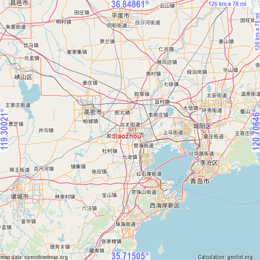
Jiaozhou GPS coordinates[2]
36° 17' 2.004" North, 120° 0' 11.988" East
| Map corner | latitude | longitude |
|---|---|---|
| Upper-left | 36.84861°, | 119.30021° |
| Center: | 36.28389°, | 120.00333° |
| Lower-right: | 35.71505°, | 120.70646° |
| Map W x H: | 126×126 km | = 78.3×78.3mi |
| max Lat: | 53.31946° ⇑22.2% North |
| Jiaozhou: | 36.28389° |
| min Lat: | ⇓77.8% South 18.22056° |
| min Long | Jiaozhou | max Long |
| 75.07348° | 120.00333° | 134.28917° |
| W 82%⇐ | ⇒18% E |
Elevation
Elevation of Jiaozhou is 10 m = 33 ft, and this is 474.8 m = 1558 ft below average elevation for this country.
| Max E: |
5622 m = 18445 ft | 89.9% |
| Avg. | 484.8 m = 1591 ft | |
| Jiaozhou | 10 m = 33 ft | |
Min E: |
-3 m = -10 ft | 10.1% |
See also: Jiaozhou elevation on elevation.city.
Geographical zone
Jiaozhou is located in North temperate zone (between Tropic of Cancer and the Arctic Circle). Distance of this Northern Tropic circle is 1428.5 km =887.6 mi to South.| Distance of | km | miles | from Jiaozhou |
|---|---|---|---|
| North Pole | 5972.7 | 3711.3 | to North |
| Arctic Circle | 3366.8 | 2092 | to North |
| Tropic Cancer | 1428.5 | 887.6 | to South |
| Equator | 4034.4 | 2506.9 | to South |


Nearby cities:
15 places around Jiaozhou: (largest is in red/bold)
• Beizhai
47.7 km =29.6 mi,  98°
98°
• Changjianglu Jiedao
38.5 km =23.9 mi,  156°
156°
• Chengyang
33.5 km =20.8 mi,  84°
84°
• Dengying
53.7 km =33.4 mi,  107°
107°
• Gaomi
25 km =15.5 mi,  296°
296°
• Jimo
42.8 km =26.6 mi,  74°
74°
• Kutao
46.1 km =28.6 mi, 109°
• Mizhou
63.2 km =39.3 mi,  239°
239°
• Pingdu
55.9 km =34.7 mi,  354°
354°
• Qingdao
41.7 km =25.9 mi,  125°
125°
• Qingshancun
62.6 km =38.9 mi, 103°
• Shazikou
51.5 km =32 mi, 111°
• Shilaorencun
48.3 km =30 mi,  115°
115°
• Yinzhu
45.1 km =28 mi,  183°
183°
• Zhu Cheng City
62.8 km =39 mi, 239°
Sources, notices
• [Note1] Compared only with cities in China existing in our database
• [Src1] Map data: © OpenStreetMap contributors (CC-BY-SA)
• [Src2] Other city data from geonames.org with taken over terms of usage.
• [Src3] Geographical zone / Annual Mean Temperature by Robert A. Rohde @ Wikipedia
