Wanrongjiang geodata
Wanrongjiang (Hunan) is a seat of a fourth-order administrative division; located in China in Asia/Shanghai (GMT+8) time zone. In our database, there are 1268 cities with bigger population. Compared to other cities in China, 71.8% of cities are located further ↑North; 72.8% of cities are located further →East and 54% of cities have lower elevation than Wanrongjiang. Note1


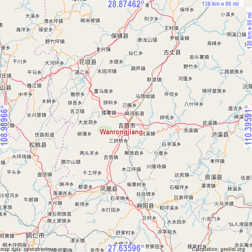
Wanrongjiang GPS coordinates[2]
28° 15' 25.524" North, 109° 41' 34.008" East
| Map corner | latitude | longitude |
|---|---|---|
| Upper-left | 28.87462°, | 108.98966° |
| Center: | 28.25709°, | 109.69278° |
| Lower-right: | 27.63596°, | 110.39591° |
| Map W x H: | 137.7×137.7 km | = 85.6×85.6mi |
| max Lat: | 53.31946° ⇑71.8% North |
| Wanrongjiang: | 28.25709° |
| min Lat: | ⇓28.2% South 18.22056° |
| min Long | Wanrongjiang | max Long |
| 75.07348° | 109.69278° | 134.28917° |
| W 27.2%⇐ | ⇒72.8% E |
Elevation
Elevation of Wanrongjiang is 197 m = 646 ft, and this is 287.8 m = 944 ft below average elevation for this country.
| Max E: |
5622 m = 18445 ft | 46% |
| Avg. | 484.8 m = 1591 ft | |
| Wanrongjiang | 197 m = 646 ft | |
Min E: |
-3 m = -10 ft | 54% |
See also: China elevation on elevation.city.
Geographical zone
Wanrongjiang is located in North temperate zone (between Tropic of Cancer and the Arctic Circle). Distance of this Northern Tropic circle is 536 km =333.1 mi to South.| Distance of | km | miles | from Wanrongjiang |
|---|---|---|---|
| North Pole | 6865.2 | 4265.8 | to North |
| Arctic Circle | 4259.3 | 2646.6 | to North |
| Tropic Cancer | 536 | 333.1 | to South |
| Equator | 3141.9 | 1952.3 | to South |


Nearby cities:
15 places around Wanrongjiang: (largest is in red/bold)
• Aizhai
12.3 km =7.6 mi,  308°
308°
• Datian
18 km =11.2 mi,  219°
219°
• Dehang
11.6 km =7.2 mi,  61°
61°
• Ganziping
7.7 km =4.8 mi,  210°
210°
• Hexi
12.3 km =7.6 mi,  107°
107°
• Jiefangyan
14.9 km =9.3 mi,  162°
162°
• Jilue
11.9 km =7.4 mi,  8°
8°
• Miliang
18.2 km =11.3 mi,  265°
265°
• Pailiao
15.8 km =9.8 mi,  326°
326°
• Qianzhou
8 km =5 mi,  29°
29°
• Sangongqiao
8.8 km =5.5 mi, 209°
• Shetangpo
9.7 km =6 mi,  251°
251°
• Shuangtang
7.2 km =4.5 mi,  169°
169°
• Taiping
16 km =9.9 mi, 64°
• Zhaiyang
7.1 km =4.4 mi, 326°
Sources, notices
• [Note1] Compared only with cities in China existing in our database
• [Src1] Map data: © OpenStreetMap contributors (CC-BY-SA)
• [Src2] Other city data from geonames.org with taken over terms of usage.
• [Src3] Geographical zone / Annual Mean Temperature by Robert A. Rohde @ Wikipedia
