Dehang geodata
Dehang (Hunan) is a populated place; located in China in Asia/Shanghai (GMT+8) time zone. With population of 2,567 people, there are 981 cities with bigger population in this country. Compared to other cities in China, 71.4% of cities are located further ↑North; 72.3% of cities are located further →East and 58.8% of cities have lower elevation than Dehang. Note1


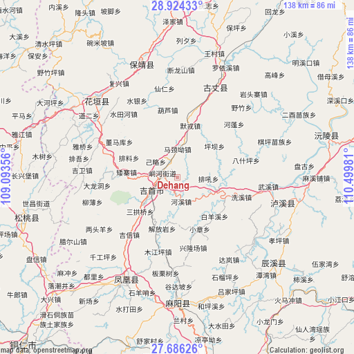
Dehang GPS coordinates[2]
28° 18' 25.56" North, 109° 47' 48.048" East
| Map corner | latitude | longitude |
|---|---|---|
| Upper-left | 28.92433°, | 109.09356° |
| Center: | 28.3071°, | 109.79668° |
| Lower-right: | 27.68626°, | 110.49981° |
| Map W x H: | 137.7×137.7 km | = 85.6×85.6mi |
| max Lat: | 53.31946° ⇑71.4% North |
| Dehang: | 28.3071° |
| min Lat: | ⇓28.6% South 18.22056° |
| min Long | Dehang | max Long |
| 75.07348° | 109.79668° | 134.28917° |
| W 27.7%⇐ | ⇒72.3% E |
Elevation
Elevation of Dehang is 245 m = 804 ft, and this is 239.8 m = 787 ft below average elevation for this country.
| Max E: |
5622 m = 18445 ft | 41.2% |
| Avg. | 484.8 m = 1591 ft | |
| Dehang | 245 m = 804 ft | |
Min E: |
-3 m = -10 ft | 58.8% |
See also: China elevation on elevation.city.
Geographical zone
Dehang is located in North temperate zone (between Tropic of Cancer and the Arctic Circle). Distance of this Northern Tropic circle is 541.5 km =336.5 mi to South.| Distance of | km | miles | from Dehang |
|---|---|---|---|
| North Pole | 6859.6 | 4262.4 | to North |
| Arctic Circle | 4253.7 | 2643.1 | to North |
| Tropic Cancer | 541.5 | 336.5 | to South |
| Equator | 3147.5 | 1955.8 | to South |


Nearby cities:
15 places around Dehang: (largest is in red/bold)
• Aizhai
19.9 km =12.4 mi,  276°
276°
• Baiyan
13.9 km =8.6 mi,  22°
22°
• Baiyan
18.4 km =11.4 mi,  70°
70°
• Ganziping
18.6 km =11.6 mi,  229°
229°
• Hexi
9.4 km =5.8 mi,  170°
170°
• Jilue
10.5 km =6.5 mi,  306°
306°
• Majing’ao
11 km =6.8 mi,  0°
0°
• Pingba
18 km =11.2 mi,  51°
51°
• Qianzhou
6.3 km =3.9 mi, 282°
• Sangongqiao
19.7 km =12.2 mi, 227°
• Shuangtang
15.5 km =9.6 mi,  215°
215°
• Taiping
4.5 km =2.8 mi, 73°
• Tanxi
15.7 km =9.8 mi,  106°
106°
• Wanrongjiang
11.6 km =7.2 mi,  241°
241°
• Zhaiyang
14.1 km =8.8 mi,  271°
271°
Sources, notices
• [Note1] Compared only with cities in China existing in our database
• [Src1] Map data: © OpenStreetMap contributors (CC-BY-SA)
• [Src2] Other city data from geonames.org with taken over terms of usage.
• [Src3] Geographical zone / Annual Mean Temperature by Robert A. Rohde @ Wikipedia
