Zhaiyang geodata
Zhaiyang (Hunan) is a seat of a fourth-order administrative division; located in China in Asia/Shanghai (GMT+8) time zone. In our database, there are 1268 cities with bigger population. Compared to other cities in China, 71.4% of cities are located further ↑North; 73% of cities are located further →East and 57.5% of cities have lower elevation than Zhaiyang. Note1


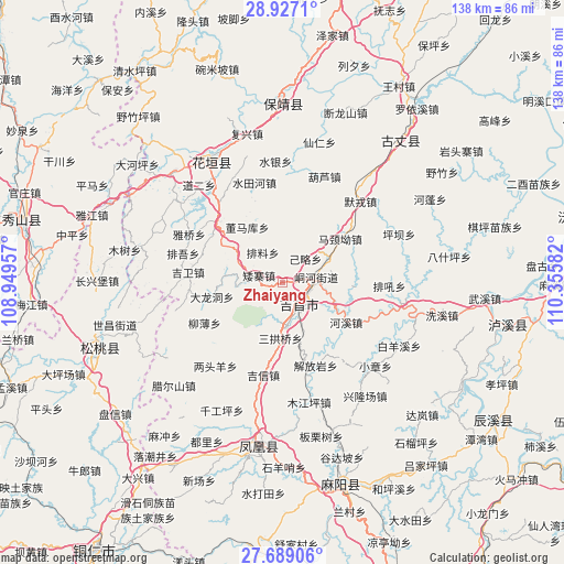
Zhaiyang GPS coordinates[2]
28° 18' 35.568" North, 109° 39' 9.684" East
| Map corner | latitude | longitude |
|---|---|---|
| Upper-left | 28.9271°, | 108.94957° |
| Center: | 28.30988°, | 109.65269° |
| Lower-right: | 27.68906°, | 110.35582° |
| Map W x H: | 137.7×137.7 km | = 85.6×85.6mi |
| max Lat: | 53.31946° ⇑71.4% North |
| Zhaiyang: | 28.30988° |
| min Lat: | ⇓28.6% South 18.22056° |
| min Long | Zhaiyang | max Long |
| 75.07348° | 109.65269° | 134.28917° |
| W 27%⇐ | ⇒73% E |
Elevation
Elevation of Zhaiyang is 230 m = 755 ft, and this is 254.8 m = 836 ft below average elevation for this country.
| Max E: |
5622 m = 18445 ft | 42.5% |
| Avg. | 484.8 m = 1591 ft | |
| Zhaiyang | 230 m = 755 ft | |
Min E: |
-3 m = -10 ft | 57.5% |
See also: China elevation on elevation.city.
Geographical zone
Zhaiyang is located in North temperate zone (between Tropic of Cancer and the Arctic Circle). Distance of this Northern Tropic circle is 541.8 km =336.7 mi to South.| Distance of | km | miles | from Zhaiyang |
|---|---|---|---|
| North Pole | 6859.3 | 4262.2 | to North |
| Arctic Circle | 4253.4 | 2642.9 | to North |
| Tropic Cancer | 541.8 | 336.7 | to South |
| Equator | 3147.8 | 1956 | to South |


Nearby cities:
15 places around Zhaiyang: (largest is in red/bold)
• Aizhai
6 km =3.7 mi,  287°
287°
• Dalongdong
17.6 km =10.9 mi,  258°
258°
• Dehang
14.1 km =8.8 mi,  91°
91°
• Dongmaku
16 km =9.9 mi,  327°
327°
• Ganziping
12.5 km =7.8 mi,  179°
179°
• Jilue
8.1 km =5 mi,  43°
43°
• Majing’ao
17.7 km =11 mi,  52°
52°
• Miliang
16 km =9.9 mi,  242°
242°
• Paibi
14.3 km =8.9 mi,  304°
304°
• Pailiao
8.8 km =5.5 mi, 327°
• Qianzhou
8 km =5 mi,  82°
82°
• Sangongqiao
13.5 km =8.4 mi, 181°
• Shetangpo
10.4 km =6.5 mi,  210°
210°
• Shuangtang
13.9 km =8.6 mi,  158°
158°
• Wanrongjiang
7.1 km =4.4 mi,  146°
146°
Sources, notices
• [Note1] Compared only with cities in China existing in our database
• [Src1] Map data: © OpenStreetMap contributors (CC-BY-SA)
• [Src2] Other city data from geonames.org with taken over terms of usage.
• [Src3] Geographical zone / Annual Mean Temperature by Robert A. Rohde @ Wikipedia
