Qianzhou geodata
Qianzhou (Hunan) is a seat of a third-order administrative division; located in China in Asia/Shanghai (GMT+8) time zone. With population of 102,332 people, there are 421 cities with bigger population in this country. Compared to other cities in China, 71.3% of cities are located further ↑North; 72.6% of cities are located further →East and 54.5% of cities have lower elevation than Qianzhou. Note1


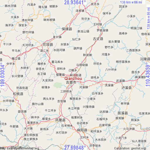
Qianzhou GPS coordinates[2]
28° 19' 9.3" North, 109° 44' 0.456" East
| Map corner | latitude | longitude |
|---|---|---|
| Upper-left | 28.93641°, | 109.03034° |
| Center: | 28.31925°, | 109.73346° |
| Lower-right: | 27.69848°, | 110.43659° |
| Map W x H: | 137.6×137.6 km | = 85.5×85.5mi |
| max Lat: | 53.31946° ⇑71.3% North |
| Qianzhou: | 28.31925° |
| min Lat: | ⇓28.7% South 18.22056° |
| min Long | Qianzhou | max Long |
| 75.07348° | 109.73346° | 134.28917° |
| W 27.4%⇐ | ⇒72.6% E |
Elevation
Elevation of Qianzhou is 201 m = 659 ft, and this is 283.8 m = 931 ft below average elevation for this country.
| Max E: |
5622 m = 18445 ft | 45.5% |
| Avg. | 484.8 m = 1591 ft | |
| Qianzhou | 201 m = 659 ft | |
Min E: |
-3 m = -10 ft | 54.5% |
See also: Qianzhou elevation on elevation.city.
Geographical zone
Qianzhou is located in North temperate zone (between Tropic of Cancer and the Arctic Circle). Distance of this Northern Tropic circle is 542.9 km =337.3 mi to South.| Distance of | km | miles | from Qianzhou |
|---|---|---|---|
| North Pole | 6858.3 | 4261.5 | to North |
| Arctic Circle | 4252.4 | 2642.3 | to North |
| Tropic Cancer | 542.9 | 337.3 | to South |
| Equator | 3148.8 | 1956.6 | to South |


Nearby cities:
15 places around Qianzhou: (largest is in red/bold)
• Aizhai
13.6 km =8.5 mi,  273°
273°
• Baiyan
16.2 km =10.1 mi,  45°
45°
• Dehang
6.3 km =3.9 mi,  102°
102°
• Dongmaku
20.7 km =12.9 mi,  307°
307°
• Ganziping
15.7 km =9.8 mi,  210°
210°
• Hexi
13.2 km =8.2 mi,  144°
144°
• Jilue
5.3 km =3.3 mi,  334°
334°
• Majing’ao
11.5 km =7.1 mi,  32°
32°
• Pailiao
14.1 km =8.8 mi,  296°
296°
• Sangongqiao
16.8 km =10.4 mi, 209°
• Shetangpo
16.6 km =10.3 mi,  232°
232°
• Shuangtang
14.2 km =8.8 mi,  191°
191°
• Taiping
10.5 km =6.5 mi,  90°
90°
• Wanrongjiang
8 km =5 mi, 209°
• Zhaiyang
8 km =5 mi,  262°
262°
Sources, notices
• [Note1] Compared only with cities in China existing in our database
• [Src1] Map data: © OpenStreetMap contributors (CC-BY-SA)
• [Src2] Other city data from geonames.org with taken over terms of usage.
• [Src3] Geographical zone / Annual Mean Temperature by Robert A. Rohde @ Wikipedia
