Dahuaishu geodata
Dahuaishu (Shanxi) is a seat of a third-order administrative division; located in China in Asia/Shanghai (GMT+8) time zone. In our database, there are 1268 cities with bigger population. Compared to other cities in China, 77.7% of cities are located further ↓South; 64.1% of cities are located further →East and 72.3% of cities have lower elevation than Dahuaishu. Note1


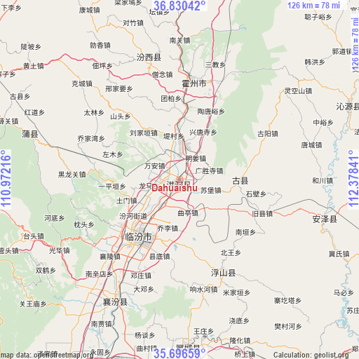
Dahuaishu GPS coordinates[2]
36° 15' 56.016" North, 111° 40' 31.008" East
| Map corner | latitude | longitude |
|---|---|---|
| Upper-left | 36.83042°, | 110.97216° |
| Center: | 36.26556°, | 111.67528° |
| Lower-right: | 35.69659°, | 112.37841° |
| Map W x H: | 126.1×126.1 km | = 78.4×78.4mi |
| max Lat: | 53.31946° ⇑22.3% North |
| Dahuaishu: | 36.26556° |
| min Lat: | ⇓77.7% South 18.22056° |
| min Long | Dahuaishu | max Long |
| 75.07348° | 111.67528° | 134.28917° |
| W 35.9%⇐ | ⇒64.1% E |
Elevation
Elevation of Dahuaishu is 460 m = 1509 ft, and this is 24.8 m = 81 ft below average elevation for this country.
| Max E: |
5622 m = 18445 ft | 27.7% |
| Avg. | 484.8 m = 1591 ft | |
| Dahuaishu | 460 m = 1509 ft | |
Min E: |
-3 m = -10 ft | 72.3% |
See also: China elevation on elevation.city.
Geographical zone
Dahuaishu is located in North temperate zone (between Tropic of Cancer and the Arctic Circle). Distance of this Northern Tropic circle is 1426.4 km =886.3 mi to South.| Distance of | km | miles | from Dahuaishu |
|---|---|---|---|
| North Pole | 5974.7 | 3712.5 | to North |
| Arctic Circle | 3368.8 | 2093.3 | to North |
| Tropic Cancer | 1426.4 | 886.3 | to South |
| Equator | 4032.4 | 2505.6 | to South |


Nearby cities:
15 places around Dahuaishu: (largest is in red/bold)
• Dadeng
40.3 km =25 mi,  198°
198°
• Dengzhuang
36.2 km =22.5 mi, 202°
• Fucheng
51.8 km =32.2 mi,  104°
104°
• Gucheng
50.7 km =31.5 mi,  219°
219°
• Jingmao
51.4 km =31.9 mi,  213°
213°
• Linfen
24.1 km =15 mi, 215°
• Nanxindian
43.5 km =27 mi, 220°
• Pucheng
54.5 km =33.9 mi,  287°
287°
• Taosi
43.9 km =27.3 mi, 201°
• Tiantan
36.5 km =22.7 mi,  155°
155°
• Xiangling
36.2 km =22.5 mi, 223°
• Xincheng
48.5 km =30.1 mi, 206°
• Xinzhi
26.1 km =16.2 mi,  5°
5°
• Yong’an
44.7 km =27.8 mi,  347°
347°
• Yueyang
21.6 km =13.4 mi,  82°
82°
Sources, notices
• [Note1] Compared only with cities in China existing in our database
• [Src1] Map data: © OpenStreetMap contributors (CC-BY-SA)
• [Src2] Other city data from geonames.org with taken over terms of usage.
• [Src3] Geographical zone / Annual Mean Temperature by Robert A. Rohde @ Wikipedia
