Puwa geodata
Puwa (Beijing) is a seat of a fourth-order administrative division; located in China in Asia/Shanghai (GMT+8) time zone. In our database, there are 1268 cities with bigger population. Compared to other cities in China, 85.4% of cities are located further ↓South; 57.2% of cities are located further ←West and 75.5% of cities have lower elevation than Puwa. Note1


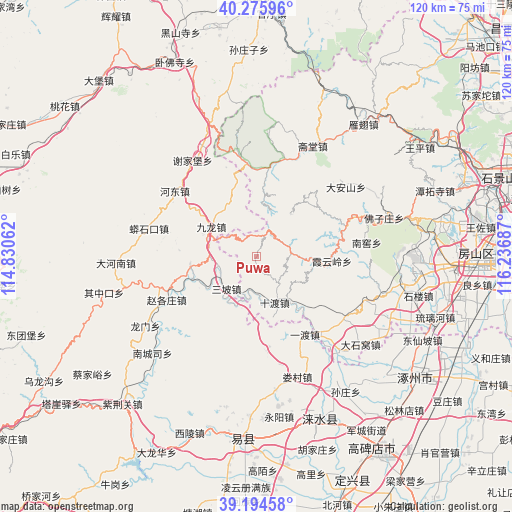
Puwa GPS coordinates[2]
39° 44' 14.604" North, 115° 32' 1.464" East
| Map corner | latitude | longitude |
|---|---|---|
| Upper-left | 40.27596°, | 114.83062° |
| Center: | 39.73739°, | 115.53374° |
| Lower-right: | 39.19458°, | 116.23687° |
| Map W x H: | 120.2×120.2 km | = 74.7×74.7mi |
| max Lat: | 53.31946° ⇑14.6% North |
| Puwa: | 39.73739° |
| min Lat: | ⇓85.4% South 18.22056° |
| min Long | Puwa | max Long |
| 75.07348° | 115.53374° | 134.28917° |
| W 57.2%⇐ | ⇒42.8% E |
Elevation
Elevation of Puwa is 532 m = 1745 ft, and this is 47.2 m = 155 ft above average elevation for this country.
| Max E: |
5622 m = 18445 ft | 24.5% |
| Puwa | 532 m 1745 ft | |
| Avg. | 484.8 m = 1591 ft | |
Min E: |
-3 m = -10 ft | 75.5% |
See also: China elevation on elevation.city.
Geographical zone
Puwa is located in North temperate zone (between Tropic of Cancer and the Arctic Circle). Distance of this Northern Tropic circle is 1812.5 km =1126.2 mi to South.| Distance of | km | miles | from Puwa |
|---|---|---|---|
| North Pole | 5588.7 | 3472.7 | to North |
| Arctic Circle | 2982.8 | 1853.4 | to North |
| Tropic Cancer | 1812.5 | 1126.2 | to South |
| Equator | 4418.4 | 2745.5 | to South |


Nearby cities:
15 places around Puwa: (largest is in red/bold)
• Changgou
35.9 km =22.3 mi,  120°
120°
• Dashiwo
31.5 km =19.6 mi,  130°
130°
• Da’anshan
26.7 km =16.6 mi,  51°
51°
• Hebei
35 km =21.7 mi,  75°
75°
• Nanjiao
26.3 km =16.3 mi, 83°
• Qingshui
24 km =14.9 mi,  16°
16°
• Shidu
11.5 km =7.1 mi,  157°
157°
• Shijiaying
17.3 km =10.7 mi,  39°
39°
• Xiangyang
36.2 km =22.5 mi,  89°
89°
• Xiayunling
17.4 km =10.8 mi, 94°
• Yanchi
39.8 km =24.7 mi, 38°
• Yanjiatai
29.4 km =18.3 mi,  4°
4°
• Zhaitang
29.2 km =18.1 mi,  27°
27°
• Zhangfang
23.8 km =14.8 mi,  141°
141°
• Zhoukoudian
34.8 km =21.6 mi,  99°
99°
Sources, notices
• [Note1] Compared only with cities in China existing in our database
• [Src1] Map data: © OpenStreetMap contributors (CC-BY-SA)
• [Src2] Other city data from geonames.org with taken over terms of usage.
• [Src3] Geographical zone / Annual Mean Temperature by Robert A. Rohde @ Wikipedia
