Yanchi geodata
Yanchi (Beijing) is a seat of a fourth-order administrative division; located in China in Asia/Shanghai (GMT+8) time zone. In our database, there are 1268 cities with bigger population. Compared to other cities in China, 86.5% of cities are located further ↓South; 59% of cities are located further ←West and 62.1% of cities have lower elevation than Yanchi. Note1


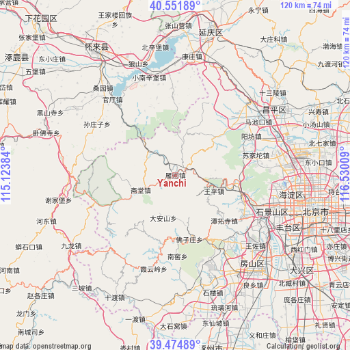
Yanchi GPS coordinates[2]
40° 0' 55.836" North, 115° 49' 37.056" East
| Map corner | latitude | longitude |
|---|---|---|
| Upper-left | 40.55189°, | 115.12384° |
| Center: | 40.01551°, | 115.82696° |
| Lower-right: | 39.47489°, | 116.53009° |
| Map W x H: | 119.8×119.8 km | = 74.4×74.4mi |
| max Lat: | 53.31946° ⇑13.5% North |
| Yanchi: | 40.01551° |
| min Lat: | ⇓86.5% South 18.22056° |
| min Long | Yanchi | max Long |
| 75.07348° | 115.82696° | 134.28917° |
| W 59%⇐ | ⇒41% E |
Elevation
Elevation of Yanchi is 285 m = 935 ft, and this is 199.8 m = 656 ft below average elevation for this country.
| Max E: |
5622 m = 18445 ft | 37.9% |
| Avg. | 484.8 m = 1591 ft | |
| Yanchi | 285 m = 935 ft | |
Min E: |
-3 m = -10 ft | 62.1% |
See also: China elevation on elevation.city.
Geographical zone
Yanchi is located in North temperate zone (between Tropic of Cancer and the Arctic Circle). Distance of this Northern Tropic circle is 1843.4 km =1145.4 mi to South.| Distance of | km | miles | from Yanchi |
|---|---|---|---|
| North Pole | 5557.8 | 3453.5 | to North |
| Arctic Circle | 2951.9 | 1834.2 | to North |
| Tropic Cancer | 1843.4 | 1145.4 | to South |
| Equator | 4449.3 | 2764.7 | to South |


Nearby cities:
15 places around Yanchi: (largest is in red/bold)
• Chengzi
23.5 km =14.6 mi,  107°
107°
• Dayu
24.6 km =15.3 mi, 110°
• Da’anshan
15 km =9.3 mi,  195°
195°
• Hebei
24 km =14.9 mi,  158°
158°
• Junzhuang
22.7 km =14.1 mi,  94°
94°
• Liucun
26.3 km =16.3 mi,  49°
49°
• Mentougou
24.2 km =15 mi, 110°
• Miaofengshan
19.4 km =12.1 mi,  103°
103°
• Nanjiao
27.9 km =17.3 mi,  177°
177°
• Qingshui
19.7 km =12.2 mi,  246°
246°
• Shijiaying
22.5 km =14 mi,  218°
218°
• Tanzhesi
23.4 km =14.5 mi,  132°
132°
• Wangping
14.2 km =8.8 mi, 112°
• Yanjiatai
22.6 km =14 mi,  265°
265°
• Zhaitang
12.6 km =7.8 mi, 247°
Sources, notices
• [Note1] Compared only with cities in China existing in our database
• [Src1] Map data: © OpenStreetMap contributors (CC-BY-SA)
• [Src2] Other city data from geonames.org with taken over terms of usage.
• [Src3] Geographical zone / Annual Mean Temperature by Robert A. Rohde @ Wikipedia
